The Badlands Be Bangin' Part 2


Badlands National Park, South Dakota
by Cassia Reynolds

:road tripping and other shenanigans in the usa
by Cassia Reynolds
by Cassia Reynolds

by Samantha Adler
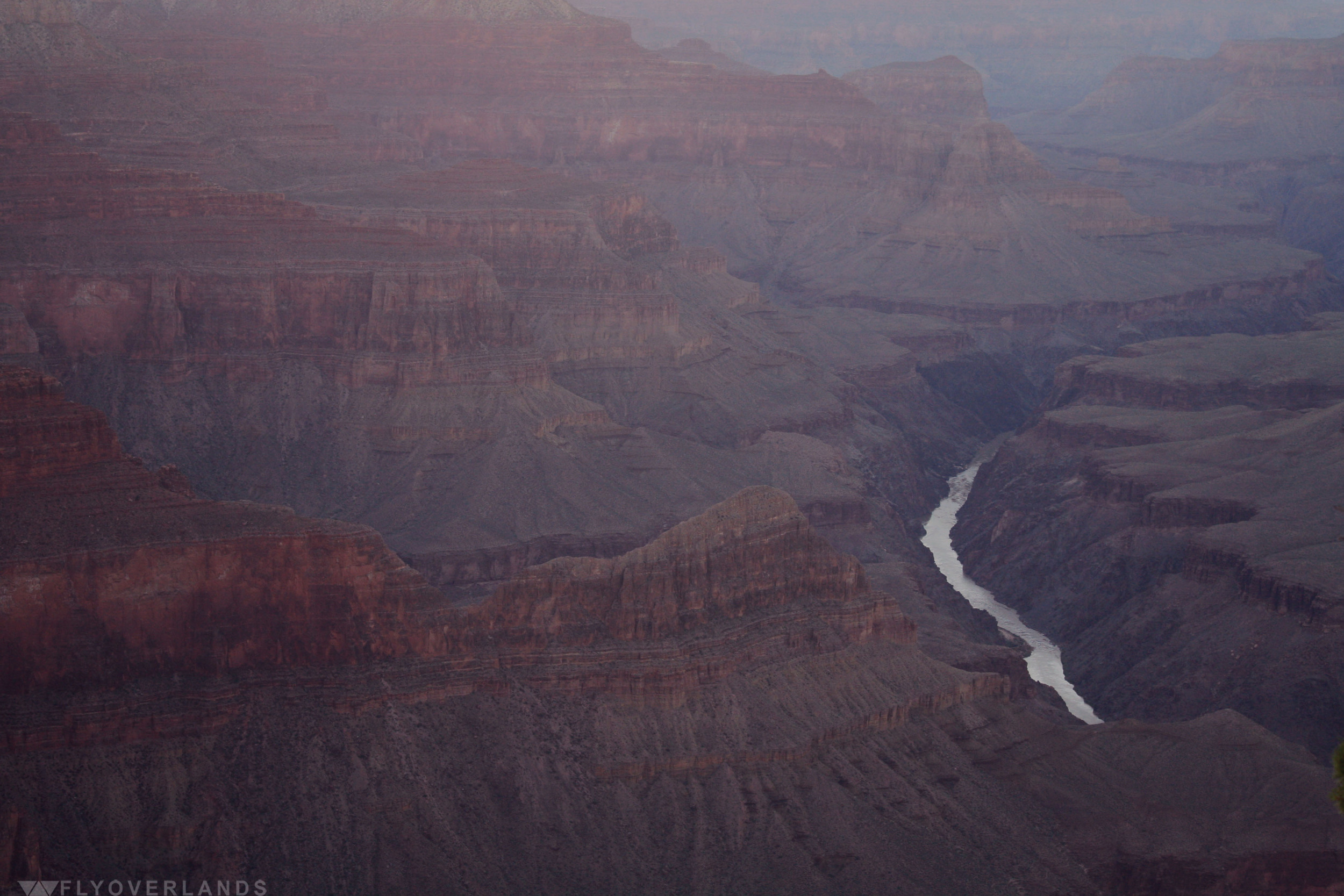
If you want a reminder that you are just a small, little speck in a huge, titanic, wondrous earth, go stand at the edge of the Grand Canyon.
I had expected it to be beautiful (it is one of the natural wonders of the world after all), but wasn’t quite prepared for its mind-altering majesty. We pulled through the park entrance and barely parked before I leapt out of the car, ran to the edge, and leaned over the metal railing in complete awe.
It’s easy to get lost in the Canyon’s beauty and forget that it’s an awesome force of nature. You’re advised only to hike in the wee hours of the morning and evening, as the sun is too powerful during the day. Fliers are stapled every five feet, with photos of 25 year old marathon runners who expired because they refused to drink the recommended amount of water and take breaks. This Canyon is not to be taken lightly, even for the most fit of us mere mortals.
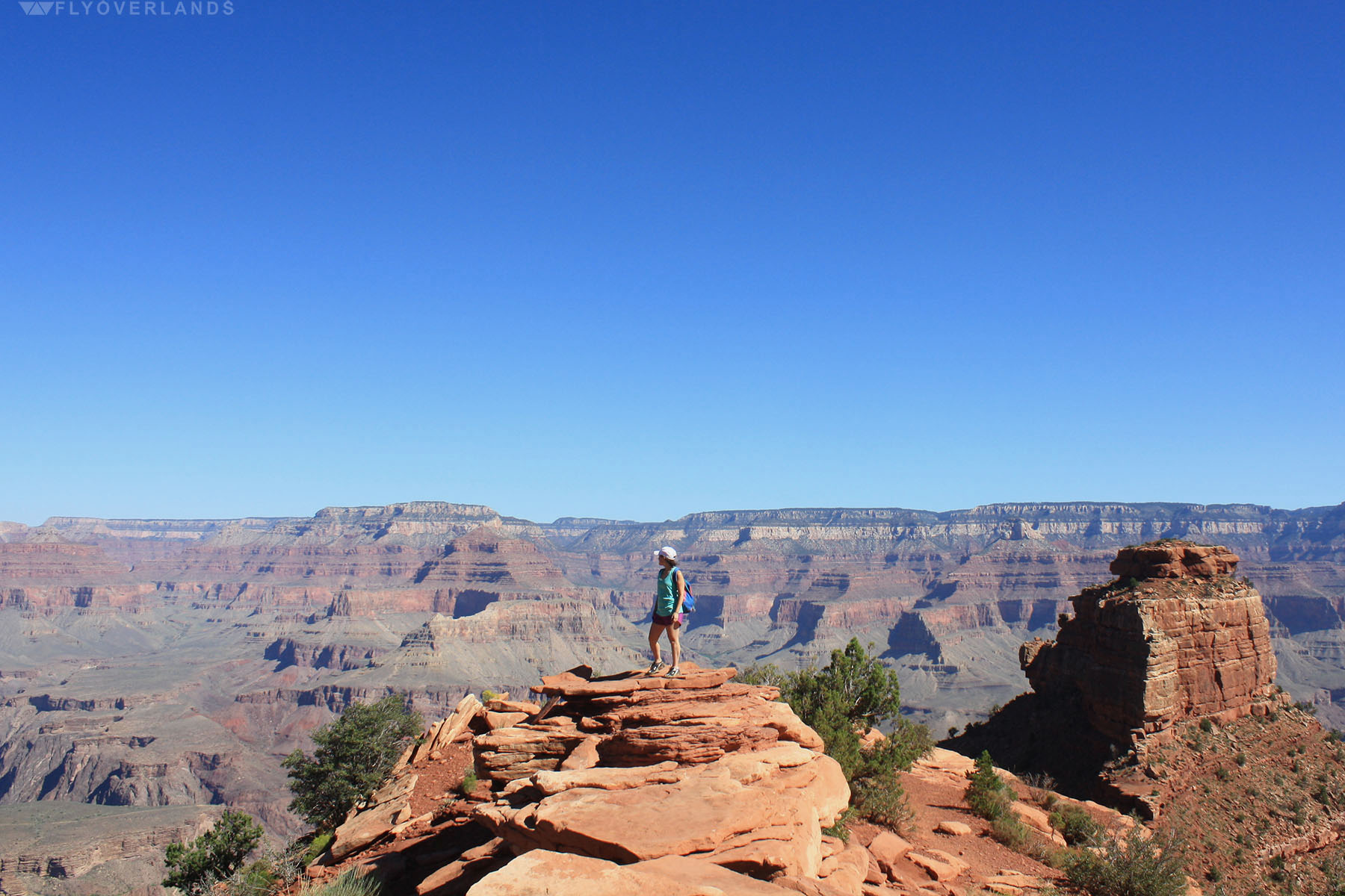
So I woke up at 5AM, hopped on the GC bus (yes, the park is so big they have a fully functioning bus system), and stumbled onto South Kaibab trail. The dusty orange path switched back and forth on the cliff face, inching slowly towards the bottom of the Canyon. With every turn my perspective of the Canyon would shift, but it never got old and it never got less intimidating.
Taking a break on a jut out, I sat beneath the one tree (and single source of shade for miles) and admired the view. Growing up I had seen this place in photos, in National Geographic, and all over geography textbooks. But, imagine tracking the southwest American wilderness in the late 1800’s and stumbling across this huge crack in the earth? I would have pooped myself (and they probably did due to dysentery).
Joseph Christmas Ives (cool name) set out to explore the Canyon via the Colorado River (what shaped this crazy structure and runs through the middle of Canyon) in 1857 on an expedition funded by the US government.
The area at the time was uncharted, just a huge blank space on US maps, so the government paid Ives to chart this area. He gathered a crew and set sail on his steamboat the Explorer (very practical, Christmas). Unfortunately, they didn’t make it far; his boat crashed at a smaller canyon right outside and they continued on foot for thirty miles, reaching an overland view of the Canyon. He wrote:
"The extent and magnitude of the system of canyons is astounding. The plateau is cut into shreds by these gigantic chasms, and resembles a vast ruin. Belts of country miles in width have been swept away, leaving only isolated mountains standing in the gap. Fissures so profound that the eye cannot penetrate their depths are separated by walls whose thickness one can almost span, and slender spires that seem to be tottering upon their bases shoot up thousands of feet from the vaults below."
It’s hard not to think in poetic prose when starring out on this vast maze of canyons.

Next up was Jon Weselly Powell, a one armed curious geologist and Civil War vet. Set out to conquer the wild Colorado (this river’s rapids are so powerful I could hear them from the overlook) with four man made wooden boats, an extensive knowledge about Ives’ journey, and ragtag team of civil war vets and trappers. The team made it further than Ives, crashing at the Lodore Canyon.
They then spent three months explore the upper canyons, eventually entering the belly of the Grand Canyon. However, by then the team had run out of food. Out of the original nine crew members, only six completed the journey. Powell named several important landmarks including the Lodore Canyon, Disaster Falls, and the Flaming Gorge.
Not to be deterred by his previous hardships on his initial journey, he returned again in 1871 with a group of scientists, set out to study the geology of the Canyon. The majesty of the Canyon changed him, and he dedicated his life to uncovering its mysteries one rock at a time. Afterwards he became the director of the U.S. Geological Survey, taking a keen interest on the geology of the American southwest.
If you’re a fit and brave soul, you can still trek to the base of the Canyon and ride the rapids of the Colorado (under the supervision of an guide and in a floaty raft). Sipping my water under the shade of a tree, I looked around at the deep and wide crevices all around me. I had walked for hours on groomed trails and I felt like an explorer. It’s not not to, despite having a path leveled for you, a hike still means braving an aggressive heat, steep inclines, and a new mind-altering view on every switch-back.
While I had set off to see a pretty sight once pictured in my text books, Powell and Ives went to study rocks in an area the government was too lazy to explore. And we had all stumbled on something that shook our foundation and reminded us we hold very little power next to a beast like the Grand Canyon.
* To learn more about the Grand Canyon explorers visit the Grand Canyon site here.

by Cassia Reynolds
Keep it chronological! Check out my other two installations on Devils Tower or risk a serious case of FOMO: Devils Tower: A Massive Mystery Rock & Devils Tower: The Perimeter
Three..Two...Go!
I heaved my torso up and over the boulder, my fingertips digging into rough stone, the rubber soles of my hiking boots bouncing off the slanted edge of a neighboring rock. When I’d dragged myself to the top, I turned to take in the view behind me: dark pine needles, crusty bark chunks, and far below, hikers milling about. The hot sun blazed down on the world, casting deep shadows in the crevices and browning my shoulders.
I dove forward, using all the momentum I could muster to throw myself across the gap to the next landing.

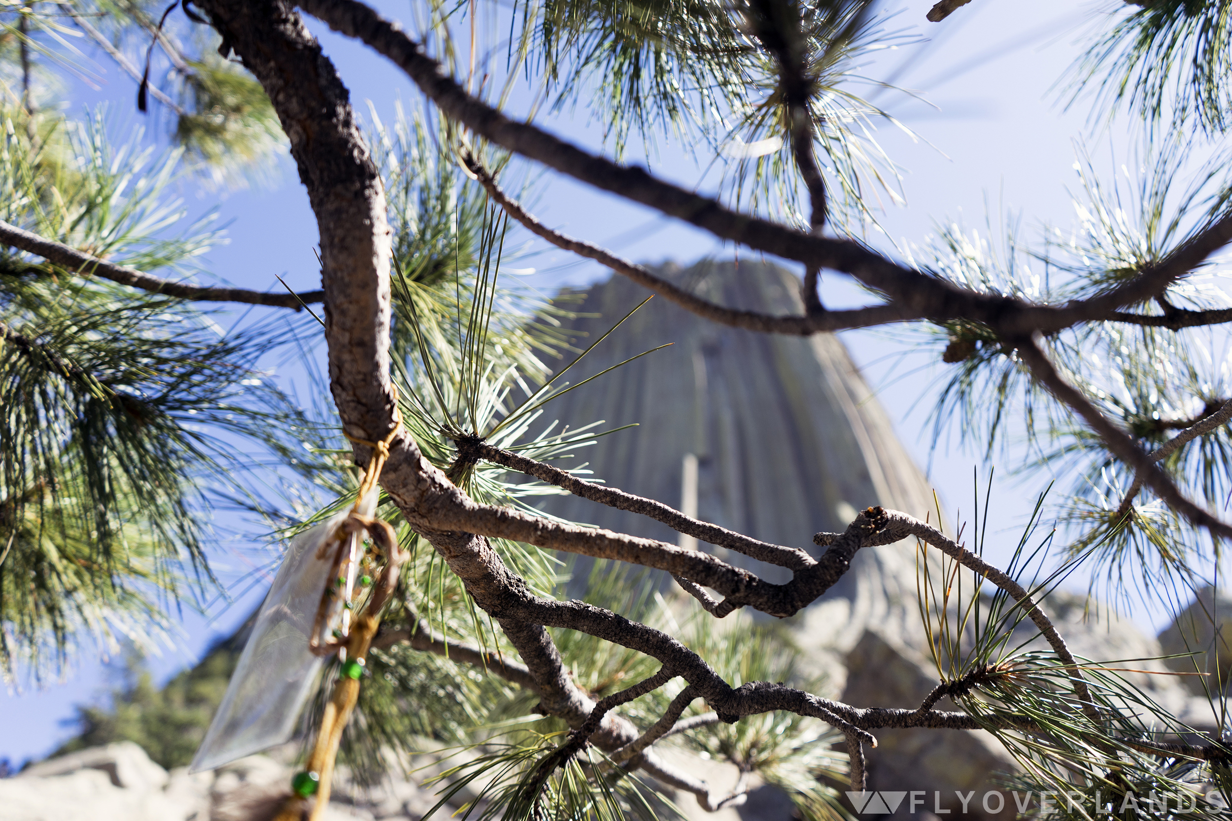
I’d been scaling boulders for at least forty-five minutes and I was only three-quarters of the way up Devils Tower’s rock fields, a graveyard of shed stone. As I moved further from the main trail, the wild hills of Wyoming became visible over the treetops of the pines. Near the highest point, I took a break, sinking down, my legs dangling off the edge of a boulder. I inspected the chartreuse lichen that grew on these Tower bits-and-pieces and wondered if this was what gave it the gray-green hue.
While resting, an unnatural glint of light caught my eye. When I turned toward it I could only see a single persistent pine wedged between the boulders off to my right. Before I moved away, the breeze came back and the reflection returned. There was something over there.
Treasure?
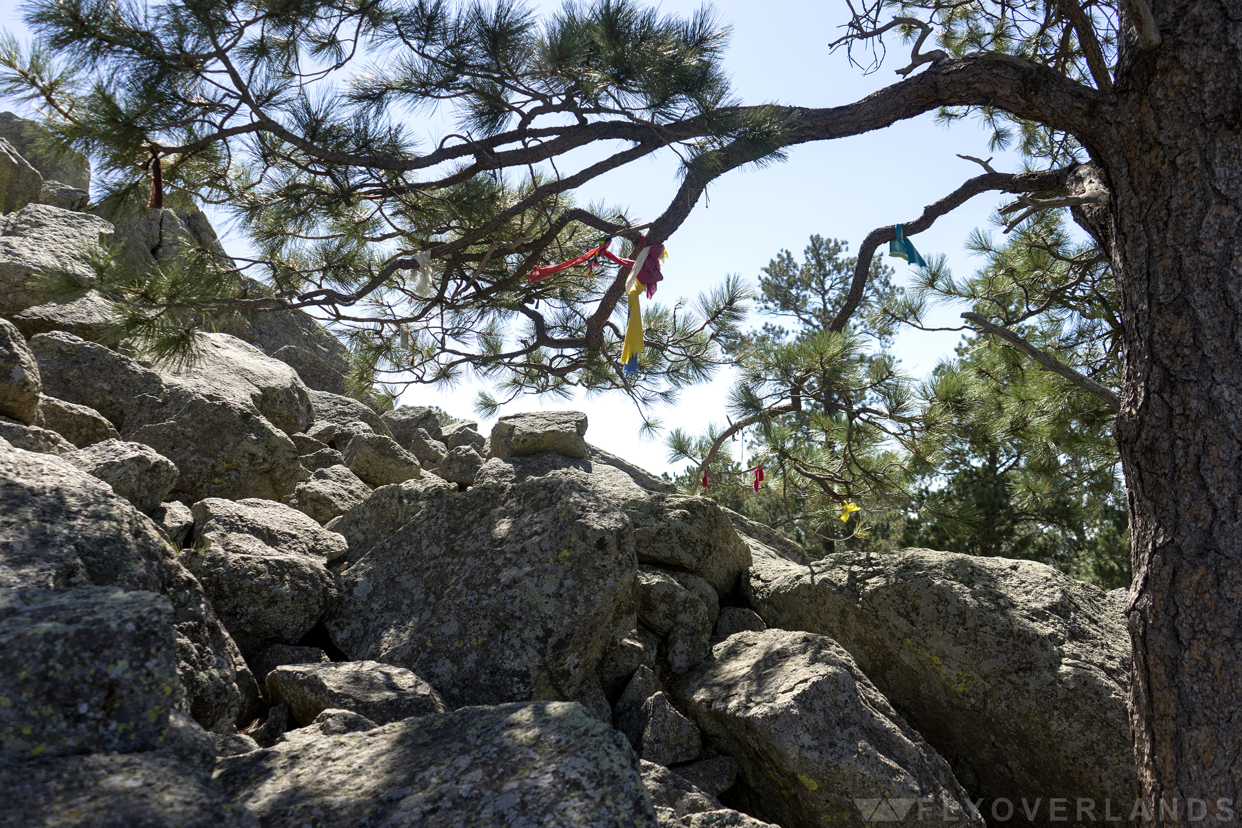
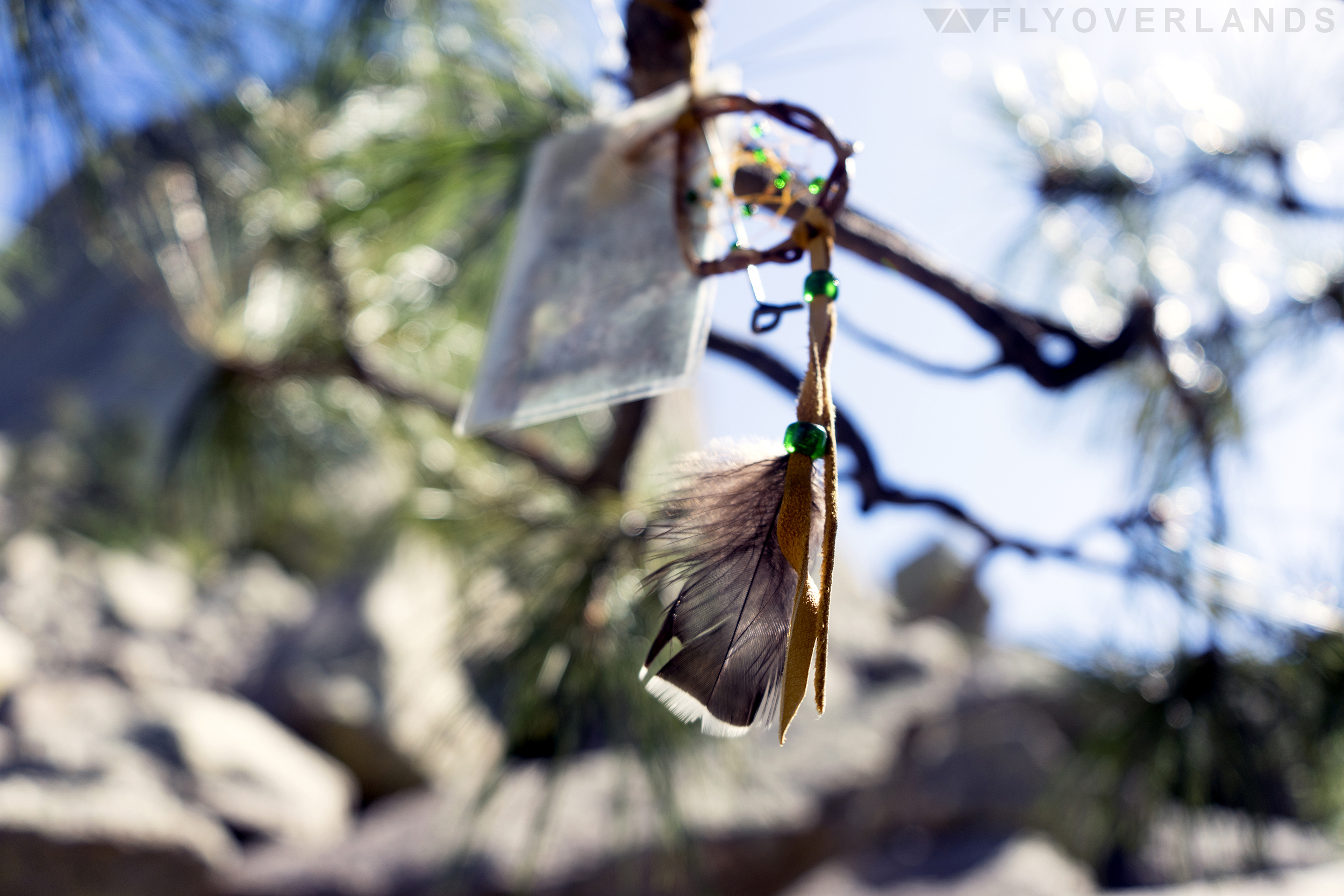
I clambered over to the skinny, twisted trees, ducked between the lowest branches, and pulled myself into their shade. And suddenly I was surrounded by colorful knots of fabric. Strips of faded red, yellow, and cream fluttered and fell with the breeze. And in the middle of it all, I found the light-reflecting culprit, a teeny dreamcatcher decorated with glittering green beads.
Tied to the dreamcatcher was a card with a print of a rose. It had been slipped into a plastic sheath to protect it from the elements. Drops of condensation stuck to transparent walls. And dangling down from the same bunch was a slender, metal branding tool with one end molded into a skinny “P.”
I admired the bundle as it spun around and around with the wind.
What I’d stumbled across was someone’s personal prayer offering to Devils Tower, a part of one of many traditional ceremonial activities still practiced by Native Americans in the Midwest, today. Over twenty tribes are connected to Devils Tower and many have their own creation story for this strange rock formation.
The foundation of many of these legends is similar: a group of children or a woman meet a gigantic bear in the woods. The bear chases them and they pray to the heavens, begging for help. The ground beneath their feet rises up, carrying them into the sky. The angry bear tries to climb the newly-and-spiritually-formed rock, dragging his claws down the sides and leaving the column-like ridges that still exist today.
In my favorite version of this tale, told by the Kiowa, it is a group of young sisters that runs from the bear. When they are lifted to the sky, they are taken so high that they become a part of night and survive today as the twinkling Big Dipper constellation.
Lying on my back below the pine, I squinted up at Devils Tower. From upside down, the ridges all along the sides really did look like claw marks.
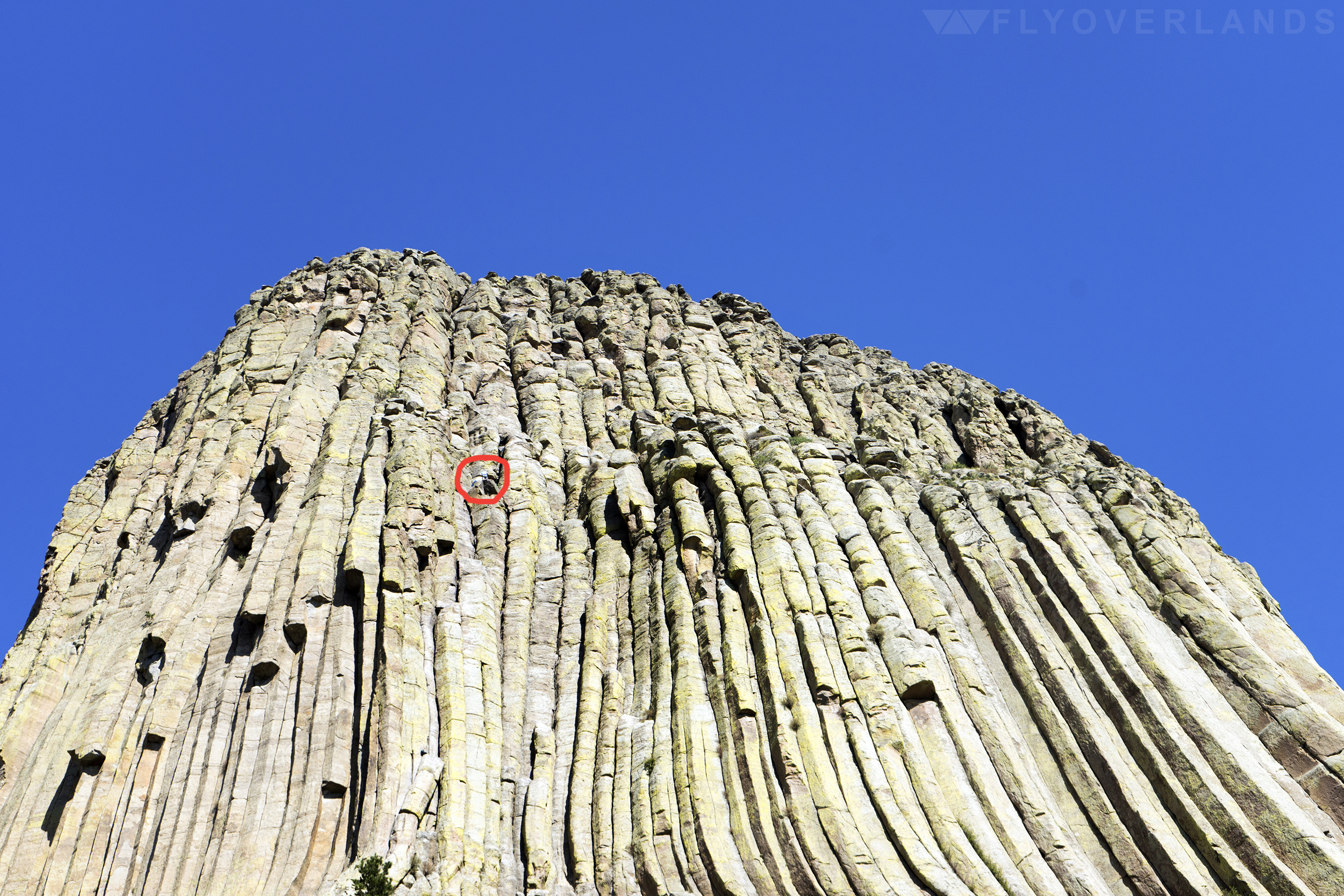
As cool as my excursion across the boulder fields was, the real adventure-seekers visit this site to crack climb its steep, choppy walls. I’m talking 127-hours style, jam-your-fingers-in-gaps-between-the-rocks-to-propel-your-body-upwards climbing. The kind of special technique that has its own equipment and grading scale. Devils Tower has multiple crack climbing routes with varying degrees of difficulty, many of which are advanced.
I saw multiple hikers on their way to the top while I wandered around the boulder fields and along the mostly-flat trails. Their tiny figures were just blobs of bright color dancing between the ledges.
While the art of crack climbing is badass, the increase of climbers at Devils Tower has caused a stir over the years. Many Native American tribes consider this recreational climbing a desecration of the sacred site. To compromise, the National Park Service has set aside the month of June, in which many Native American celebrations surrounding The Tower occur, as “Voluntary Climbing Closure” month. It’s not mandatory to respect this tradition, but it’s suggested, and the the act has resulted in an 80% reduction of climbs during the month of June.
It’s a start.
The confusion and miscommunication between Native Americans and the American Government has been a long running theme (as we all know but especially) at this first national monument. Long before it was dubbed Devils Tower, it was known to Native Americans, among other names, as Bear Lodge or Bear Rock. The oh-so-Satanic namesake realised from a misinterpretation of the original name in 1875. A colonel interpreted “Bear Tower” as “Bad God’s Tower” which eventually led to “Devils Tower.” Still no explanation for that (aggravating) missing apostrophe, though.
The idea of a national monument, where the US government rushes to decree ownership over a piece of land or a memorial, offers a glimpse into the minds of American leaders of the past; what makes each one important and why? And most importantly, to whom are they important?
I sat up and brushed off the dust from my back, preparing to leave the little dreamcatcher and the prayer cloths, and as I did, I wondered if Devils Tower was less a tourist attraction and more a sacred space. And if this mini-sanctuary was hidden on purpose by its founders.
As I contemplated the teachings about Native American beliefs from my middle-school-days, I realized that ownership of this land didn’t matter. There was no “ownership” of nature, no real way to say that a rock was America’s besides a piece of paper with a list of “rights” on it. It was all Mother Nature’s, and that’s something that we need to respect.
A piece of paper can fade, can flutter away in the wind.
by Cassia Reynolds
Check out my other installations on Devils Tower or risk a serious case of FOMO: Devils Tower: A Massive Mystery Rock & Devils Tower: Beneath the Pine
by Cassia Reynolds
When I think of American national monuments, Mount Rushmore, the Statue of Liberty, and the Lincoln Memorial come to mind. But these are just a few of the United States’ 120 protected landmarks. And after some digging, I’ve come to find that they’re more like child pop stars than proper representations of the average American national monument (read: overhyped, overwhelmed with paparazzi, and a lot smaller in real life).
A little background before we get into this: a national monument is a protected area, man-made or natural, that has been established by a US president by proclamation or through the Congress by legislation. These declarations preserve public lands from private development and allow the federal government to name any place on US soil not-to-be-fucked-with in the name of historical or scientific interest.
Basically, the government is that super anal coworker who doesn’t like when other people misplace his stuff, so he takes out that label-maker he keeps in his cubicle (you know who I’m talking about) and goes around sticking his name on every stapler, pen, and coffee mug he has laid claim to. And if he catches you with any of it, it’s all dirty looks and a call later that week from HR.
“Hey Dana. Just got off the phone with Fred, again. I know, I know. I hate his label maker, too. But please don’t hide it in the freezer...or hang it from the ceiling above his desk...or (sigh) replace the label tape with a roll of images of Nicolas Cage. It really upsets him. If you touch it again, I’m going to have to call a mediation meeting. And neither of us wants that.”
But, in the national monument world, instead of a mediation meeting, you end up in prison. Which is probably worse?
Anyway.
The more research I’ve done on American national monuments, the more I’ve learned that these are way cooler than just historical statues. They’re more like Government Sanctioned Ultimate Celebrations of the Weird. (Yay, Science!) And the prime example of that is the first named national monument, an unnatural, natural thing (because, seriously, I don’t know what to call it) out in the middle-of-nowhere Wyoming: Devils Tower.
Good ol’ Teddy Roosevelt proclaimed this first national monument when he visited Devils Tower in 1906. He traveled for weeks to get to Wyoming in response to reports he’d heard of a strange rock formation out in the plains.
Think about that for a second; the President of the United States took a month out of his presidency to go visit a “strange rock formation.” That’s crazy! And it’s not like nothing was going on in 1906. That same year, the San Francisco Earthquake and the Atlanta Race Riots happened, and then Teddy took a trip to Panama to oversee the building of the Panama Canal, and on top of that was awarded a Nobel Peace Prize just a couple months later!
That man was hella busy.
I do wonder why, out of all of America’s wild landscapes, this is the one he chose to name the first national monument. Maybe it was the mystery of the place that caused it and drove Mr. President to see Devils Tower. Even in the age of the Internet, this tall, cylindrical mass of Phonolite porphyry is mysterious as fuck. There is still no certainty about the history of it, though scientists have theorized that it may be the leftovers of a mega-volcano or a laccolith (an igneous rock that protrudes through sedimentary rock). The Kiowa, Lakota, and Sioux tribes all have their own legends about Devils Tower, as well. But nobody really agrees on a single explanation for it.
And here I am, over 100 years later, paying tribute to this same strange rock formation that Teddy did, with just as little scientific understanding of it, and just as much passion for the weird and wonderful of America. Sometimes I think the United States’ motto should be changed from In God We Trust to Let Your Freak Flag Fly.
I stumbled upon this grand American freak-scape by accident, as it goes with most of the best experiences.
I was a few days into a two-week road trip to Montana. I’d packed up camp in the Smoky Mountains and pulled the pickup into Knoxville for a break before another long day of driving. I stretched in the shadows of the tall, old brick buildings that lined the quiet street, waiting impatiently until the bars began the day’s sales.
After what seemed like forever (about 15 minutes), I was sitting in a creaky leather booth between some arcade machines and brightly painted guitars, cracking open a local Tennessee Stout (I’d had a rough night and my travel buddy, Diego, had already promised to take the first driving shift).
It was then, as I swallowed that first gulp of delicious deliverance, that I received that fateful, automated call from the National Park service in Montana.
“Your reservation at Glacier National Park has been cancelled due to high levels of negative bear-human interactions in the park. You have been refunded for your deposit. Have a good day.”
That was it. I stared at my phone in shock, half-expecting the robot voice to let out a metallic chuckle and say “just kidding - be sure you check in before noon on the date of your arrival!”
It was almost insulting, the finality of the message. There was no call back number, no person to even ask questions to. It was over. I was halfway across the country with a fully-packed truck bed of camping gear to a no-go. I had a friend, Mara, in North Dakota waiting for me to pick her up...but no destination.
(Side Note: this was one of the few trips I’d planned extensively instead of just jetting off. And look at what happened. The world is obviously telling me to give up on any notion of planning and to just roll with it.)
But the road trip must go on. And, as we continued our journey up through the deep Midwest to meet Mara, Diego and I began to Google the “best camping spots” before we hit the Rocky Mountains.
And that’s how I eventually stumbled upon a review for Devils Tower, a kind of watering hole for wanderers in the empty expanses of plains that otherwise make up the western Midwest. I did a single Google image search of Devils Tower and was spellbound by this massive middle finger to gravity. In less than a week, I’d picked up Mara and me and my two buddies were in Wyoming, rocketing along a worn, windy trail to a new destination.
The Tower became visible miles before we actually reached the monument; it rose up from the valleys and sloping hills of Wyoming’s rolling landscape like some gargantuan, prehistoric tree trunk, chopped clean through by an axe. The way that the afternoon light hit it left the other side encased in shadows. It was creepy and magnificent.
The road ended at the base, where a KOA Campground had set up shop - it was one of those fancy campsites with a general store, showers, and even an ice cream stand. I guess it’s necessary to have the essentials when you’re stranded a good hour from the nearest grocery store.
Once we arrived, we constructed our tent, admiring the burnt red clay beds that surrounded us, the deer running through the camp in broad daylight. It seemed like a bit of a paradise from society. It was quiet, there was no cell service, and Devils Tower rose up beside us, colossal and confusing. It was so big that the sky seemed even bigger surrounding it.
I remembered a favorite quote of mine from that cowboy classic, Lonesome Dove. And I smiled to myself when I realized that in the book, the main characters, Augustus McCrae and Woodrow Call, began their adventure on a wild journey to Montana.
Full Disclosure: I fell in love with the character of Augustus McCrae for a short while. If you haven’t read Lonesome Dove, do yourself a favor and get lost in this lost land of cowboys and frontiers.
Augustus’s words rang in head as I looked across all of Mother Nature’s bright colors engulfing me and the green-gray shadow of Devils Tower.
“It ain’t dying I’m talking about, it’s living. I doubt it matters where you die, but it matters where you live.”
As I write this, I’m sitting in a cafe, still reeling at my good fortune of grabbing the parking space in front of the building. People crowd around little tables that have been pushed together to make room for more little tables and I have organized all my things so they take up as little room as physically possible...and still it seems like I’m exploding into the space of my neighbors. I like working here with the noise and the business and the aroma of coffee keeping me wide-eyed and alert. Sometimes it’s nice having a private moment in the crowded public sphere. But it’s strange comparing this world to the endless emptiness of Wyoming, with its infinite skies and equally vast green landscapes.
The idea of space is just...different out there. Everything is bigger because it can be.
And still, Devils Tower appears larger-than-life, a jaw-dropping vision of Earth’s most unbelievable possibilities. And sometimes, you just need to see this kind of thing, a reminder of the power of Mother Nature and of the smallness of humanity in the expanse of time, space, and life itself.
If there’s one thing that looks small compared to Devils Tower, it’s people.
Our first night we snuck in late to the campground’s daily showing of Close Encounters of the Third Kind. It was pretty awesome; they had a television plugged in right in front of Devils Tower, so we were facing the real deal even as we saw it in the movie. Meta, huh?
We snagged a few plastic chairs in the front and as the movie began to play, we could hear the muffled hops of rabbits in the grass, the odd hoot of an owl, and the wind rustling leaves. As the aliens began to communicate with the Earthlings and the night darkened to a purple-black, it felt like the 1970’s-poor-quality of the film was made up for by the real thing surrounding me. The depth of stars above me, the way that Devils Tower blocked a portion of the sky, sucking in the light.
It was the first time I’d ever seen Close Encounters, and I was thrilled by the campy-ness, the very ET-esque feeling of interacting with aliens, of optimism and celebration of the believer, the weirdo.
In that glittering, glowy evening, I couldn’t help but think, “you know what? We can’t be the only ones out here.”
Maybe that’s what Teddy was thinking, too.
Check out my other installations on Devils Tower or risk a serious case of FOMO: Devils Tower: The Perimeter & Devils Tower: Beneath the Pine
by Samantha Adler

So this conversation happened.
And it got the road warriors in us thinking about where we would want to end up in the United States if (read: when) the inevitable zomb-pocalypse actually happens.
Here are the results, because, as resident America cross country travel experts (read: enthusiasts) we’ve scoped it out for you. And we don’t want to leave the good people hanging when the undead come a-knocking.
I’ve been binge watching an unhealthy amount of The Walking Dead. While Georgia is gorgeous and the forests provide good cover from the swarms of zombies, the cast always looks hot (sexy and sweaty), hungry, and far from everything.
So...my zombie apocalypse go-to would have to be the California coast. Why you ask?

A. Climate
A mild climate seems huge for survival...and comfort. If you’re low on water you don’t want to overheat and if you’re without shelter or fire you don’t want to be somewhere with tons of snow fall. Also I think we’re allowed to enjoy the ocean breeze if were running from zombies all day, am I right?
As you travel south to north, the climate changes but stays pretty temperate. This allows you to change up the scenery, but never run into extreme weather.
B. Shelter

California is heavily populated with tons of places to set up camp. There are more houses, factories, schools, hospitals...etc. The coast is also diverse in that you can bop into a city or run inland to a forested area for cover.
Also (taking a hint from Woody Harrelson in Zombieland), you could always pop over to the Hollywood Hills and set up camp in an A-Listers mansion. Big fences, lots of space, and probably well stocked.
The ocean is also HUGE. If things get too crazy on dry land, steal a boat and anchor for a few weeks.
C. Food
Walking corpses roaming the earth should not stop you from enjoying a trendy avocado toast once in awhile. California’s climate is great for growing fruits and veggies. And with an abundance of farms, you can load up and learn how to grow them yourself. You also would have the ability to fish on the ocean.
WINE. There are a ton of wineries on the California coast. The vineyards might be abandoned, but wine only gets better with age right?
The zombie diet: wine, fish, fruit, and veggies. I feel like Gwyneth Paltrow would be really into this.
D. Weaponry
Dotted with cities and highly populated towns, the coast will have restaurants full of knives and guns abundant. The ocean is again a huge asset here. There are several marine army bases on the coast. Big guns on boats? Yes.
So if the dead start walking the earth, head west. We’ll get a tan on while we kick zombie ass.
As indecisive as I am about what I want to eat for dinner on a daily basis (but is there really a straightforward answer when you’re choosing between tacos at the Mexican place down the street, Southern barbecue, and Chinese leftovers?), I have thought long and hard about where I would want to be if the zomb-pocalypse ever became a viable threat to my safety. Zombies aren’t difficult to study; watch the movies and you learn enough about their undead nature to construct a tentative sketch of their strengths and weaknesses (i.e. strength: can smell human flesh miles away, weakness: not very good at walking up stairs). And so it is without a doubt that I can say at the slightest hint of this cannibalism-disease bearing down on America, I’d drop my life in Atlanta (apologies in advance for betraying you, my lovely city, and your cult-like following of The Walking Dead) and make my way to Charleston, South Carolina.

A. Climate
It’s simple geography. Charleston is a city built almost as if with the intent to prepare for the zombie-pocalypse and protect inhabitants from these mutants. The seaside provides mild winters to prevent frostbite during a long, electricity-less winter (though the smell of rotting corpses in the summer may be a bit of a con). It’s also surrounded by farmland and maintains perfect weather for growing vegetables and fruits.
B. Shelter
At the city’s core is a marina, where there is a bounty of oysters to dig out for food and plenty of snazzy yachts and boats just waiting for someone in need of escape from the undead. The marina itself is framed by historical, pastel-colored, colonial-style mansions (read: mini-fortresses). These gated, four- and five- story homes of yesteryear boast fireplaces, tons of staircases, and lots of rooms to barricade oneself in. There are big windows on the upper floors to open up during the sweaty summertimes and I’m sure at least a few of them still have an outhouse in the backyard (you have to prepare for everything).
C. Weaponry
Charleston’s has deep South roots. It’s the kind of place where one can pretty easily find the #1 Zombie-Re-Killing Weapon (according to the resident experts; 28 Days Later, Dawn of the Dead, Zombieland, World War Z, and Warm Bodies): the shotgun. I figure that in Charleston, not only am I going to be able to access plenty of shotguns and ammo at the nearest Wal-Mart Superstore, but I’ll be able to find a few other survivors who already know how to hunt (or attend Charleston’s military school, The Citadel) and can bring down a zombie while wasting the least amount of shells per undead monster (thanks for the lesson in survival, Zombieland).
D. A Fortress
And last but not least, there’s the fortress on an island just a little ways offshore. Yeah, that’s right. If the zombies overcome all your blockades and you run out of ammo and you’re in a pinch, you can just steal away on one of those yachts and make your way to a fabulous island paradise for fun-in-the-sun while you wait out the end of the world as we know it.

by Samantha Adler
Tis the age of the selfie. That iPhone front camera has created a world where the duck face is a coveted skill and Kim Kardashian is a bestselling author.
While it’s easy to lose patience with the selfie and its rule over your social media feeds, it’s not completely evil. A selfie can be the ultimate tool for a solo adventurer looking to document their travels. And no, you do not have narcissistic stockholm syndrome.
I’m admittedly a culprit of the selfie epidemic (hey, sometimes you can’t let a good hair-day slip by unnoticed). But, my real internal, ethical struggle lies with the selfie’s trusty sidekick: the selfie stick.
A tool used only for the most serious front-cam-glam, I didn’t think we’d ever become acquainted. But, when strolling down the aisles of the Target picking up supplies in preparation for my roadtrip, there it was on sale for $5.
Memories of New York City tourists huddled together, smiling creepily too hard, blocking the sidewalk with a metallic stick stretched out above them were seared into my brain, telling me to walk away if I wanted to maintain any sort of dignity. But, the humor of owning one was too good and I caved.

Tucked away in the corner of my ratty backpack, I forgot about the selfie stick until I was well into my roadtrip. I had left the familiar landscape of the Northeast and the cities along the way, and was now immersed into the vast landscape of the West. Here nature was grander, bigger and sprawling.
I snapped photos on my camera and a few on my phone, to send to family and friends. But as far as I stretched or jumped or climbed, I couldn’t capture the titanic landscapes and natural wonders. One of the most challenging to capture was the Grand Canyon. After trying to snap a photo of me with the canyon behind me, I was frustrated. The photos were 70% my sweaty face and 30% beautiful landscape.
Frustrated, annoyed and hot, I furiously wrestled through my bag for my water bottle when my hand hit something cold and metallic: the selfie stick. I pulled it out, slid my phone into the grip and connected the cord. Holding it close to me, I scanned the ledge for fellow judgmental hikers. I was safe to test this baby out.

Stretching out the metal pole, I lifted it up so the camera was well above my head and started clicking away. The grip wasn’t screwed in tight enough, the camera whirled upside down and swung its weight to the side. I lost balance of the over extended metal rod and fell over. This tool I had mocked was now testing me.

I checked the photos I snapped before securing the grip. While I hadn’t figure out how to get the entirety of the pole out of the photo, it captured a large part of the landscape behind me. After several tries with happy results, I was giddy. I didn’t even wince when other hikers passed and giggled. With a handful of approved selfies on my camera roll, I set off the path grinning with my new selfie-stick-pal.
I had underestimated the usefulness of the stick. It proved to be a really helpful tool for documenting adventures that are bigger than an arm’s length. Go forth, adventure and selfie away.
by Cassia Reynolds
Let’s talk zen.
For those of you that aren’t acquainted with casual yogi-lingo, zen is that special headspace that you can discover through relaxation and meditation. The official definition, as dictated by the great-and-all-knowing wordsmiths of Merriam-Webster, describes zen as an approach to an activity, skill, or subject that emphasizes simplicity and intuition rather than conventional thinking or fixation on goals.
I’m all about the zen life, whether that means diving into deep-deep-thought while driving down a long stretch of Interstate emptiness; staring out over a morning mountainscape, soaking in the soft, ethereal joy in the dewy mist; vibing to Kurt Vile’s latest album while banging out a blog; or filling my lungs with air to prepare for the all-encompassing hum of the classic yoga “om.”
Zen is everywhere, all the time, just waiting for you to reach out, grasp it, and pull yourself into its illuminating embrace.
And if this sounds like big talk, it’s because zen is bigger than big; it’s transformative. Especially when you’ve been on the road for 14-hours, hunched over your steering wheel and all you can think about is the sore-itchy-stabbing sensations in your lower back. And that’s where all this yoga-talk comes in.
I guarantee that by adding a little yogi-goodness to your road trip routine, you will not only feel better at the end of those long hauls, but you’ll also gain a little bit of zen in your life.
So here’s the 101’s of my stretch-life routine, one that has, on many long drives, evolved my physical, mental, and spiritual self from a grumpy, butt-ache low to a grinning, walking-on-sunshine-effervescence-for-life high.
Why? Because my body has been twisted, stretched, and strengthened. And my mind has been wrung out, mellowed, and soaked in a big old dose of zen (it’s pretty much my athletic version of pouring a frosty beer into a tumbler on a hot summer afternoon and plopping down in a rocking chair in the shade, listening to nothing but the birds chirping and the breeze in the trees).
The Sun Salute
It’s the break of day and you have a long way to go, too much to do and see. There’s not time to get into a whole hour-long yoga sesh. Instead, I recommend a quick, painless-but-tingly, wake up routine: the sun salute. Warm your muscles up, get your mojo going, and put a smile on your face in 15 minutes or less.
I was first introduced to the three-step sun salute by an Australian snowboard-enthusiast with a never-healed-right knee injury. He said that this routine had made sports possible for him again. We used to practice them together before we would head out surfing on the weekends in Newcastle, NSW. And there’s nothing better than warming your body up a little before leaping into some icy Pacific waves.
A fun fact about yoga: all it requires is a mat and an area wide enough that you can stretch your arms out fully and lay down flat. Nothing else. I’ve seen people practice in jeggings (seriously!) so you have no excuse. Clear a space on your campsite, in your hotel room, behind your car at a rest stop, beside your friend’s couch, and remove your shoes, close your eyes, and breath.
The steps are basic, but effective:
To check out my favorite Sun Salute playlist, see my Guide for Strange Travels.
The New Classic View
Standing poses and headstands are a funky, heart-thudding way to appreciate a breathtaking view. What can I say - I’m a thrill seeker. And nothing gets my blood pumping faster than balancing myself on the edge of a cliff and seeing the whole world flipped upside down before me.
If you’re new to yoga, headstands are not something that’s immediately mastered - but they’re doable with practice, patience, and a growing comfort with one’s own body. They need to be worked for, just like you worked to hike up that mountain and witness that beautiful landscape.
Evening Benders
It’s nighttime and not only are you sore and exhausted, but you head is throbbing with that so-much-activity-in-one-day daze. Well, this next move can get you back into your groove. Work your back out with camel or bridge pose, and, if you’re up to it, a full backbend.
So there you have it - a little bit of zen-fabulousness to crack your road trip routine. And I am no expert! I’m just a girl that loves that one-with-nature-vibe and gets a rush from standing on my head on cliffs. If I can do it, you can too. I hope this inspires you to follow your own zen flow - and let me know if you find your own favorite travel move!
Om out!
by Cassia Reynolds

by Samantha Adler
Florida palm trees, luxurious naps and bingo: these are the things retirement dreams are made of.
But, if you travel up to woodsy New Hampshire and ask Maureen and Larry Gelo they’d beg to differ. A couple of retirement rebels, these two fill their time seeking new adventures on America’s open roads, breaking away from the status quo of retirees.
The two lived, worked and raised their children in Connecticut. He worked as a police officer in a small town on the shore and she worked as a nanny. Larry’s a handyman who can fix all and create any device you’d ever need from scratch. Maureen’s gentle and loving with a dash of cheeky spunk. After retiring at age of 62, they bought a motorhome and set off on a series of spontaneous road trips in North America, driven by curiosity and an unfulfilled wanderlust. It’s been over a decade and they’re still going, insisting there is so much to see in this big, beautiful country of ours.
This pair of serial roadtrippers happen to be my grandparents (+10 cool points for me) and two of the biggest supporters of the road trip. I recently visited them in Unity, New Hampshire, their home base. When they’re not out on the road, Larry does woodwork with materials from the forest behind their house (Check out some of his amazing work), visit friends, hike and enjoy their rugged New England home.
Before settling down over the kitchen table, we went on a short hike in the nearby Quechee Gorge. A few remaining leaves hung off wiry branches, clinging on against the chilly late autumn breeze. We got home, tore off hiking boots and unbundled. After putting a log on the furnace, we gathered around a plate of brownies and they shared their stories, travel advice and all their coveted road trip knowledge in their usual hilarious banter.
First off, why the travel retirement?
L: There’s a lot of places we’ve never been and we’d like to go there.
M: That pretty much says it all. We just wanted to travel and see this beautiful country.
Why roadtripping in particular?
L: Because you can see a lot more. And with a camper you can stop wherever, whenever and for as long as you want.
M: To get off the beaten path and see things. We’ve had so many surprises, especially in these little towns along the way. [There was] one place in Nebraska we ended up. It was the end of the day and we were tired. We just about got into this parking lot, when we saw there was a museum. Well, we ended up staying there for three more days because this museum was blocks long. A man had collected everything from soup to nuts; from cars to buttons. And he had all these buildings with all these wonderful things, like the earliest telephone. We found out that he was the creator of bubble wrap! And he just collected for years and years and years. But like I said when we pulled into this place it looked like nothing, it was just a place we stopped at because it was the end of the day and we were tired. So that’s the wonderful thing about traveling across this country in a vehicle.
Did you travel when you were younger?
M: I think the farthest we ever went was to visit my father’s sister in New York. And that was about three or four times in my childhood. Neither of my parents liked to travel, they were homebodies. So that gave me the wanderlust.
L: When I was single in the service and my teenage years, I used to travel down the East Coast, and that was it. But I did get to go to college in Alaska and loved it. About forty years ago we got the chance to take a cruise up there and loved it. Then we went back and spent eight or ten weeks traveling around in the motorhome.

What was your first road trip?
M: We had a trailer and we went up to Canada, Quebec and Niagara falls, on both sides. There again, we found this wonderful little town that we would have never found if we weren’t riding around.
L: We first started with a truck, we camped in the back of the truck, then we got a little trailer, then we got a little bigger trailer and then we decided [to get the RV] when we got close to retirement.
What was the best trip or route you’ve taken?
L: I think Alaska was probably the greatest. They’ve all been great. One time we went down Route 50 from the East Coast all the way out to California. It was the old 1950/60’s. Most of it’s disappeared by now, but it was kind of nostalgic and off the beaten path. It was stuff we remembered from when we were young.
M: Route 66.
L: Yea, a lot of it was Route 66. Another time we went along the Canadian border all the way west, then down the coast to San Francisco and then back along the southern coast. That was an amazing trip.
What was the craziest thing you saw because you were driving?
L: We’ve seen just about everything. We’ve been in tornados, major thunderstorms, hailstorms, windstorms where we thought the camper was going to flip over. Anything you can think of we’ve been near it, too near it for comfort or right in the middle of it.
Have you made any friends along the way?
L: We’ve met all sorts of people. You never know who you’re going to run into. We stopped in one place in Canada and met people we’ve been in touch with for seven or eight years now.
M: All nice people from all walks of life.
L: Everyplace you stop you should talk to somebody. You’ll talk about where you’ve been and where you’re going and they’ll tell you what you should go and see. And if they’ve been to places you’ve already been, they’ll tell you about places you missed after you thought you’ve seen everything there is to see. We went to Wall Drugs a few times going across country. It’s a big, big drug store and big tourist attraction. And almost across the street, were the Badlands. We drove right by it. The third time we finally figured it out after chatting with people.
What are the best things you’ve picked up along the way?
L: She likes to shop. We had to go all the way to Alaska to go to Walmart.
M: No. My best souvenirs were in Sequoia National Park, we filled our trunk with great big pinecones.
L: Then we found out it was illegal.
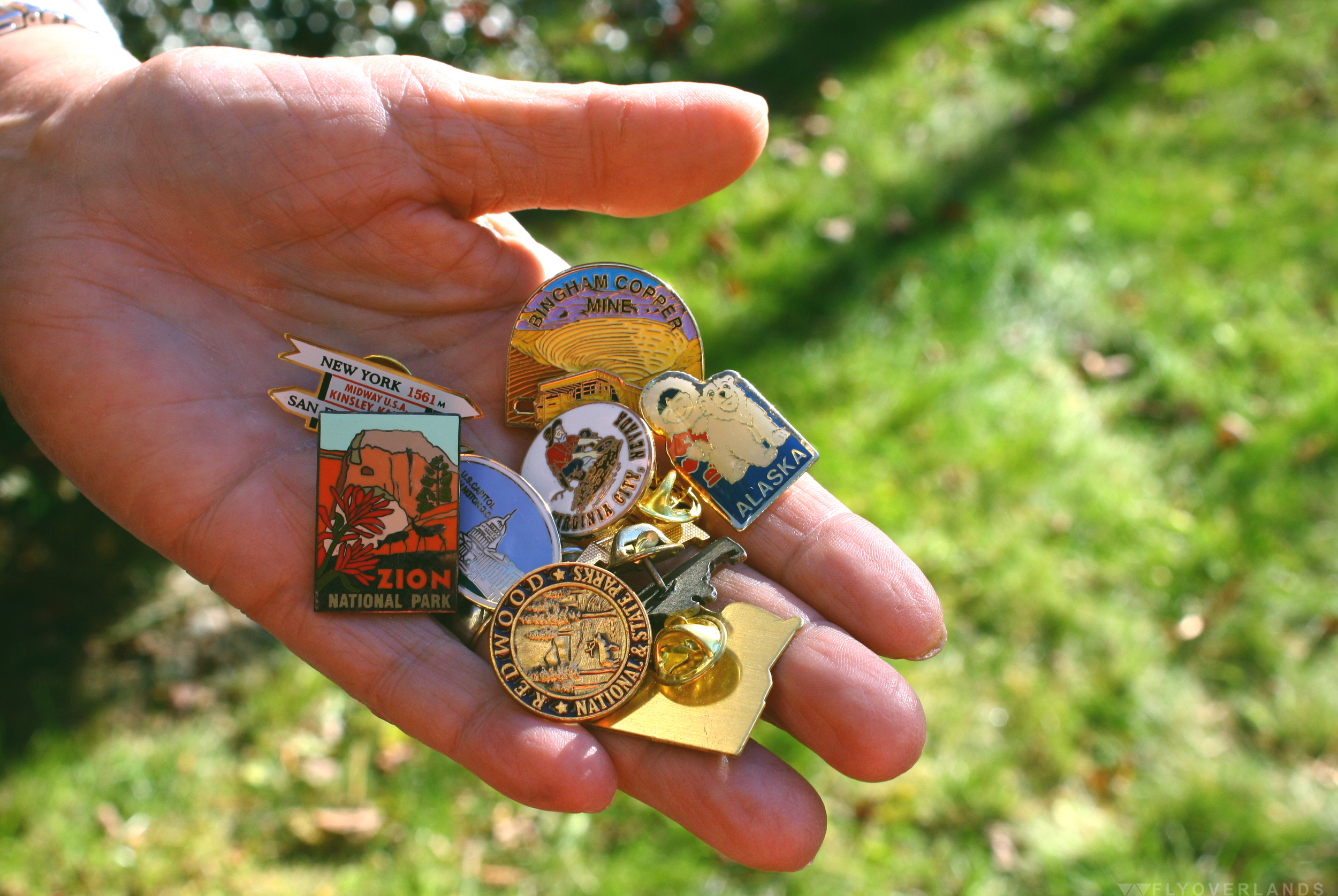
M: And then I got a piece of wood from the Petrified Forest. Which was...another illegal thing. Nothing I bought. I have a chunk of rock from the base of Crazy Horse. And that was legal! They said I could take it.
L: Every place we’ve gone to I’ve gotten a walking stick emblem.

I know you’ve had some run-ins with pretty large critters.
L: We saw every animal you could think of in Alaska: mountain lions, moose, bears. I’ve walked up on a moose. Not intentionally. I was walking along the road and right next to me a moose started snorting. I said “oh that’s not a smart idea.” I kept walking and he went back on to minding his own business.
Advice for aspiring roadtrippers?
L: It’s the most exciting way in the world to go. You don’t have to go on an airplane and go through all that crap. Travel as much as you can. You get a whole, totally different outlook on the world. You see it’s more than this little town you live in.
M: Enjoy the ride and the surprises. In Saint Louis we ended up seeing the Clydesdales from the Budweiser commercials at Grant’s Farm. That was a surprise that we came upon. It was in this beautiful nature park that had all types of animals. And it was totally free.
L: Talk to everyone you can talk to.
M: I like stopping at visitors centers because you can get all the information you need. It’s always good to stop there.
L: If you see something interesting you should stop. The most important thing about traveling like this is being able to stop when you see something interesting and if you don’t make your destination, fine.
The one place you must see in the US?
M: Grand Tetons.
L: When we were traveling to a balloon festival in Arizona, we hit every presidential library in the country. That was amazing, I never knew the presidential libraries had so much to offer.
What route do you recommend for someone who wants to road trip for the first time?
L: I think Route 50 was one of the nicest. If you can stay off the main highways, do it. The interstates are beautiful things for when you want to get somewhere fast, but you miss everything.
There’s so much to see. What should someone base their route on when planning?
L: No matter what you’re interested in look for things that are in that area. Like history, if you’re interested in battlefields you could spend months visiting them all in the southeast. Or if you find a writer you’re interested in...anything!
M: Just seeing the country and riding along.
L: We’ve got friends who like to go to zoos. They just travel all around the country going to zoos. It’s whatever you’re interested in.
M: I wanted to go to Savannah because I heard there was a museum here that had Scarlett O’Hara’s dress from Gone with the Wind. I was so excited because that’s one of my favorite movies. I never thought i’d be able to do that. Especially because I never traveled when I was younger, so it’s amazing to be able to hop in the motorhome, drive down and see something as ridiculous as Scarlett O’Hara’s gown.
L: One time we tried to hit as many national forests and parks as we could.
Has anything you’ve seen changed your perspective?
L: It’s changed our outlook on life. Before we started traveling the north east was basically it. Yea, I’d gone down south a few times for the service. But I’ve probably never gone more than 100 miles from the Atlantic Ocean. And it’s amazing. I thought everyone in the world lived in New York City; that was civilization. Then you find out Chicago is bigger. And the first time we went across country, to see how big this country is, where you’re driving and you can see fifty miles ahead, drive for hours and see nothing else. You can’t wrap your head around that or visualize that from reading a book or watching TV. You can’t appreciate it until you see it. And to see how different people live. It’s changing a bit now. But we’d hit totally different cultures and foods. I do carpenter work and I’ve seen carpenters make the same thing I make but in totally different ways, with different tools and different methods. That’s where you learn things.
So, you guys are the cool nomadic kids in your friend group.
M: Yea.
L: We dare a little more.
M: Some of our friends don’t follow us cause they feel we’re too old. They don’t want to get off the beaten path.
L: We’ll just go and if we stop, we’ll stop. We’re a little more daring, but everyone is different. It’s still nice to get home. Then regroup, reorganize and then take off again.

by Cassia Reynolds
Disclaimer: I know cartographartist isn’t a real word. But it should be.
I first discovered the work of Dave Imus, the founder of Imus Geographics and winner of four top national awards for cartography (as well as six other runner up places), while on a mission to find a map to represent the Flyoverlands logo.

Samantha and I had already spent a week searching for the right map to fit our vision. We wanted something detailed, readable, and representative of the actual landscape of the United States. Basically, we wanted the map to demonstrate what we hoped to do with our blog: explore America. We’d both noticed a trend in the maps we’d found so far; they were very colorful and overwhelmed with labels, but not particularly informative of the nature and distinctions in US geography.
The hunt led me to a Slate article about Dave’s most famous map, The Essential Geography of the United States of America, which won the Best of Show award by the Cartography and Geographic Information Society in 2012. From afar, it looked like a simple, 4ft x 3ft rendering of the United States. It was pleasing to the eye, a well-shaded illustration of geographic changes with clear lines marking state borders, rivers, mountains, and other important landmarks. However, the real genius of the map is in the attention to detail; I learned Dave illustrated and labeled his work over the course of two years. He included 1000 iconic American landmarks and did it all without sacrificing topographic detail for political information.

When I reached out to Dave about possibly using his illustration for the Flyoverlands logo, he not only agreed to it, but to an interview as well. And that’s how I got a little one-on-one time with the man who single-handedly beat out big companies like National Geographic and Rand McNally for this prestigious award in mapmaking. And I found out that not only does Dave not have formal training specifically in cartography, but that he really only started Imus Geographics back in 1983 because his lack of experience meant he couldn’t land a job as a cartographer.
Over the course of a half hour, we discussed Dave’s love of road trips, his beef with geography in the American education system, and the DL on what really goes into making one of his mapsterpieces (BAM I’m on a roll today).
Tell me about your work as a cartographer.
I have very little in common with my colleagues across the country. I live in a pretty artistic community, Eugene, Oregon, and I have way more in common with woodworkers and painters and sculptors than I do with mapmakers. I’m an illustrator, an artist. And mapmaking is primarily a technical activity. It’s data manipulation and interpretation and once this data is somehow represented, it’s done. It’s like, “We have the data published!” And [I say], “Oh yay, that’s a good place to start. Now let’s make a beautiful illustration that really says something.”
What goes into making a map? Does it require you to experience the places you’re mapping out?
If I’m mapping a city I’ve never been to, I want to capture the essence of that city. So I read about it and I study large scale maps of it to see which of the principal routes I want to put on my map and what, if any, iconic landmarks are there that sort of identify it as a place. And so I experience the place whether I’ve been there or not. I’ve got to contemplate it and try to make sense out of it so that somebody who’s looking at my map will know the basic geography of the place just like people who live there.
What’s been your most difficult project and your favorite project?
The way that my career path has gone is each project is more difficult and more fun. For many years I have worked with a colleague in Massachusetts. And we were talking about how complicated we make things. And he said, “You know, if it were easy, we wouldn’t be interested!” And I said, “You know, I think you’re right.” But the US map took everything I knew about map making and geography to do it.
What do you want people to know about your award winning map, The Essential Geography of the United States of America?
The big thing really about that map is that it’s made with an entirely different standard of artistry than American cartographers embrace. I control every detail of the map so it’s all my interpretation of how best to communicate the geography of one area. I’m not letting algorithms do a dang thing. I use a computer but I use it as a drafting tool. So the map has far greater clarity. It’s just easier on the eye and more acceptable to the mind. And the other thing is that it’s the only map of basic geography. It shows where the country is forested and where it’s not. It has the principle populated places so people know what the important locations of an area are. And it’s got stuff like “the Bluegrass Country of Kentucky” on it. Because we care about these places but we don’t know exactly where they are.
Do you see your work as an education tool for others?
In primary and secondary education, geography bores even me. It’s treated like some sort of abstraction. Look up a map by Rand McNally or National Geographic or United States Maps and they treat the world like it’s some sort of abstraction that doesn’t even really exist. [Their maps] might look like a moonscape. They’re just a whole bunch of bright colors but they’re not illustrations of the land. A good map is an illustration of the land first and it’s only a map because you put type tables on it. If you’re not illustrating the land with the artistic attention of a botanical illustrator or a medical illustrator, then you’re not illustrating the land in a way where people can actually make sense out of it. You don’t actually have to see a wild iris because people draw beautiful pictures of them. Nobody draws beautiful pictures of basic geography and puts these labels on them so we know what we’re looking at.
As someone that’s spent so much time going over America’s geography, what are three pieces of advice you have for the American road tripper?
I’m an expert road tripper by the way - I’m exploring all the time. This traveling partner [and I] go on trips for a couple thousand miles and we don’t drive an inch on the freeway. You see so much more of America that way. I mean this is planet earth we’re talking about here! Which as far as we know is the most exotic planet in the universe. So you know whether you’re out in the middle of Kansas or you’re in the canyon lands of southern Utah, it’s beautiful and interesting.
Tell me something you love about the USA.
We have so much to learn from each other. I think that some time in the future, and I hope it’s not too long, people will come from all over the world to visit our Native American reservations. They don’t have them anywhere else. You can still go to the Hopi reservation and, man, people are living there the way they’ve been living for 2000 years basically. They’re still doing the same ceremonies and stuff and it’s really cool.
Dave has now begun a quest to break down the boundaries further between cartography and fine art, transforming his geographic illustrations into high-quality canvas prints that highlight the beauty and intricacy of landscapes. His individual pieces focus on regions like the Great Lakes, or single states, like Iowa and Alaska. They expose the details of the cities, roads, forests, and mountains of these areas in a totally new light.
Or, as Dave put it, “Every state looks cool. Iowa looks cool!”
His current show, “ReEnvisioning Maps: The Cartographic Art of Dave Imus,” in the gallery space of InEugene Real Estate in Eugene, Oregon, began on November 6 and runs through December 2015. Check out the press release for more information, visit Dave’s website, and/or Like Dave's Facebook page, The Essential Geography of the United States of America.

by Cassia Reynolds
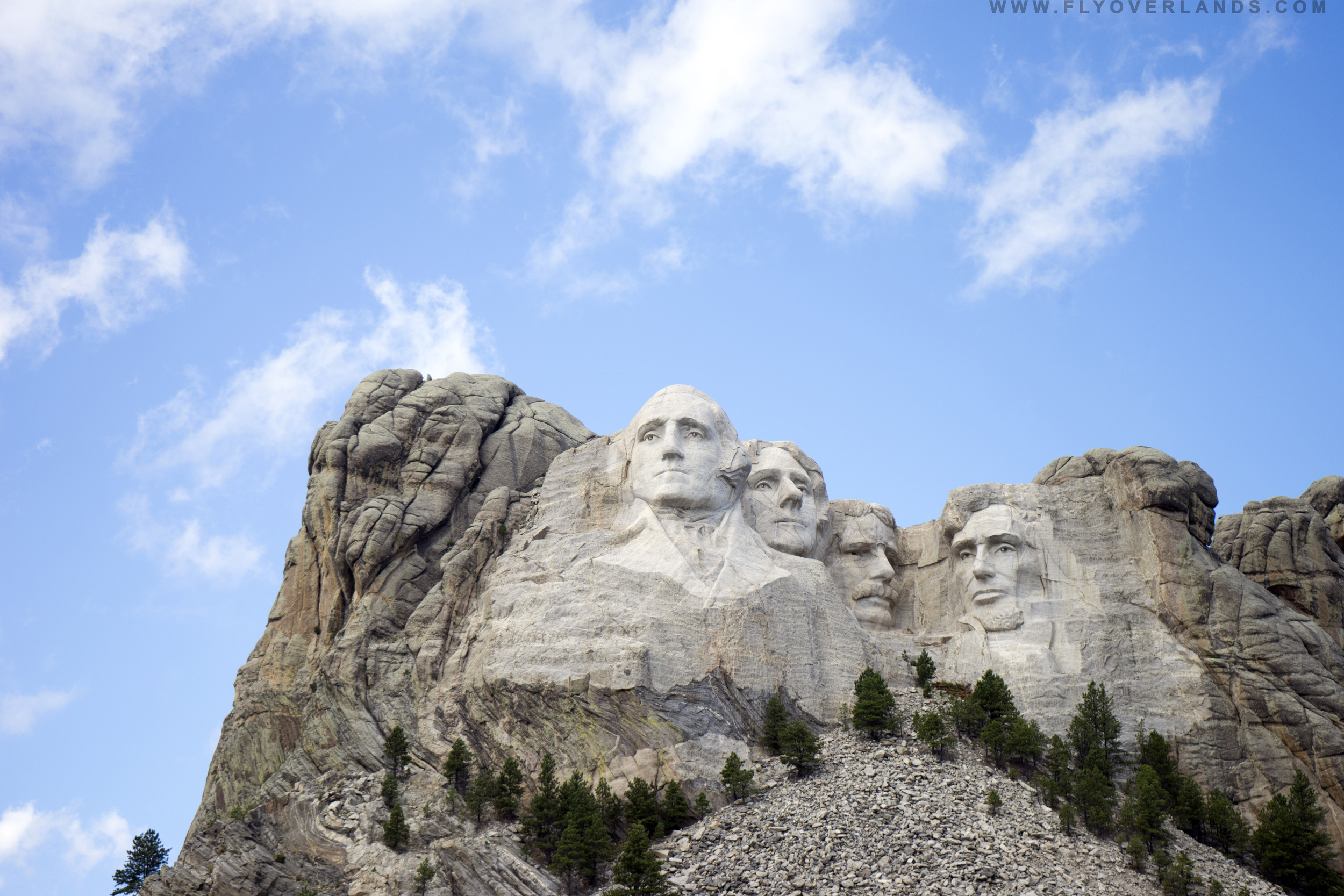
My friends and I stared at Mount Rushmore for the recommended 10 minutes (how long can you really look at a statue in the distance?). After we perused the equally gigantic maze of the accompanying gift store, we wandered back onto the crowded walkway where I immediately lost my buddies in the mob of tourists. I couldn’t see over the sea of shoulders (thanks again, genetics) so I climbed on top of a stone post for a better view. After a few futile minutes of scanning the masses for familiar faces, I gave up and sat down on the pedestal to wait for them.
While I waited, I flicked through the images on my camera. I noticed I’d only taken a few snapshots of the actual monument. This didn’t concern me; it was like photographing the Mona Lisa or the Statue of Liberty. Pictures just don’t do justice to an in-person visit to such a grandeur piece of history.
Instead, my memory card was chock full of photographs of random tourists who were hanging out at the national memorial. And that’s when it hit me: a profound understanding of why I felt that visiting Mount Rushmore was such an important cultural experience. The actual presidential portraits were just happenstance. It was the swarming hordes of American people who, like me, had flocked to this place, drawn by a desire to witness this historical landmark. It was the fact that though we came from totally distinct parts of the country and lifestyles, we all somehow felt so connected to Mount Rushmore that we traveled (sometimes for weeks) through plains, forests, mountains, and deserts to see it. This place was truly a crossroads of American life.
And so to conclude my Mount Rushmore series, I give you my interpretation of this American cultural experience through a collection of scenes:


by Cassia Reynolds
Check out my first Mount Rushmore installment: Unnatural Habitats.
The sun’s rays shone bright on the pale, creamy stone faces set against the Crayola Cornflower Blue backdrop. Afternoon shadows accented an overhanging brow, a stern jawline, a pensive gaze. A soft, surreal daze settled over me as I stood on the viewing platform before Washington, Jefferson, Roosevelt, and Lincoln, ruminating on the postcard perfect scenery.
Do these sculptures feel so familiar because they’re accurate representations of the presidents whose faces I’ve memorized over the years? Or has Mount Rushmore so shaped my mental image of these presidents that looking at it in person just affirms my vision of these men?
It wasn’t until later that I learned the incredible efforts undergone to position Mount Rushmore to leave viewers like myself so spellbound: the visionary’s tireless quest for the landscape with perfect lighting and texture; the two full years of sculpting that went into the original bust of Jefferson, just to be dynamited and repositioned on Washington’s right; and the thousands of measurements that were calculated and then multiplied by twelve to recreate the original model of the four figures. (Check it out.)
But in the present moment a vivid but brief movie clip materialized in my memory. It was a scene from the 1994 Macaulay Culkin classic, Ri¢hie Ri¢h. Ri¢hie and his mother were perched on the edge of one stone eye socket in Mount Ri¢hmore, clinging desperately to each other. Ri¢hie’s dad dangled perilously (and ironically) from the carved glasses on the nose of his own likeness.
I squinted hard at Mount Rushmore, wondering if my childhood truths could possibly have grounding in reality. But if there were any doorways set in the pupils of the monoliths, they were invisible from this distance. The sixty foot replicas of America’s great leaders stared blankly ahead, unwilling to give even the barest of hints.
So instead I Googled. And not only did I find out that in 1998 the National Parks System constructed a Hall of Records within the memorial that contains sixteen porcelain enamel panels detailing the Constitution, the Declaration of Independence, and other historic records, but also the background of one of America’s most iconic national memorials.
As with most wildly passionate, ambitious projects, a crazy man was at the center of all the fuss. In this case, a crazy Dutch-American man named John Gutzon de la Mothe Borglum: an Idaho-born, eccentric perfectionist, Ku Klux Klan sympathist, nativist, painter, and (of course) sculptor.
Borglum was, while extremely qualified to construct larger-than-life replicas of famous national figures, also known for being hot tempered, egotistical, and more than a little batshit. He’d actually quit the last project he’d been commissioned to work on in Georgia (a memorial to the heroes of the Confederacy with a side altar dedicated to the KKK) in a rage after a dispute with the association, smashing all his clay and plaster models during his dramatic exit.
Side note: As unfortunate and disrespectful as it is, given Borglum’s history, it makes sense why he chose the American presidents for his work instead of the Native American leaders whose sacred land he worked on.
Borglum was born in 1867 to one of the wives of a Mormon bigamist. His father worked as a woodcarver before attending Saint Louis Homeopathic Medical College and opening his own practice in Nebraska. When he was sixteen, Borglum studied art in Los Angeles, specializing in painting, and married a divorcee eighteen years his senior. After a few more years training in Paris, Borglum made a sudden switch to sculpting (rumors go that it was just to compete with his younger brother, Solon, who was already an established sculptor). For more information on Borglum, check out his biography on PBS.
In a selection from a Smithsonian article on the history of Mount Rushmore, his son, Lincoln Borglum, describes his father’s perspective on art.
Borglum was of the mindset that American art should be “…built into, cut into, the crust of this earth so that those records would have to melt or by wind be worn to dust before the record…could, as Lincoln said, ‘perish from the earth.’” When he carved his presidential portraits into the stable granite of Mount Rushmore, he fully intended for the memorial to endure, like Stonehenge, long past people’s understanding of it.

As I learned about Borglum, I began to think of his as a true American frontiersman tale, one that follows the age-old rule of the Wild West where he built his tribute: there are no rules in Freedomland. If you’re crazy enough to dream it and persistent enough to find a way to fund it, you can do it...even if your dream is to construct presidential portraits that withstand written human history. Though it’s still to be seen if Borglum’s work survives past modern American textbooks, to one day become as mysterious in origin as Stonehenge, it is already as internationally renowned.
I’m left wondering what’s really crazy here. Is it Borglum’s grandiose dream? Or that almost a century after the artist first laid eyes on this piece of granite, I’m standing before it, contemplating how Mount Rushmore has shaped my perspective on American patriotism?
by Samantha Adler
Visiting Mesa Verde was a very last minute decision inspired by a curiosity stemming from foggy memories of middle school history books and the fear conjured by my neighbor of the previous campsite: a single man/possible serial killer who stayed up all hours of the night scribbling his manifesto in the middle of the Colorado forest armed only with a pen, piles of paper and a hatchet.
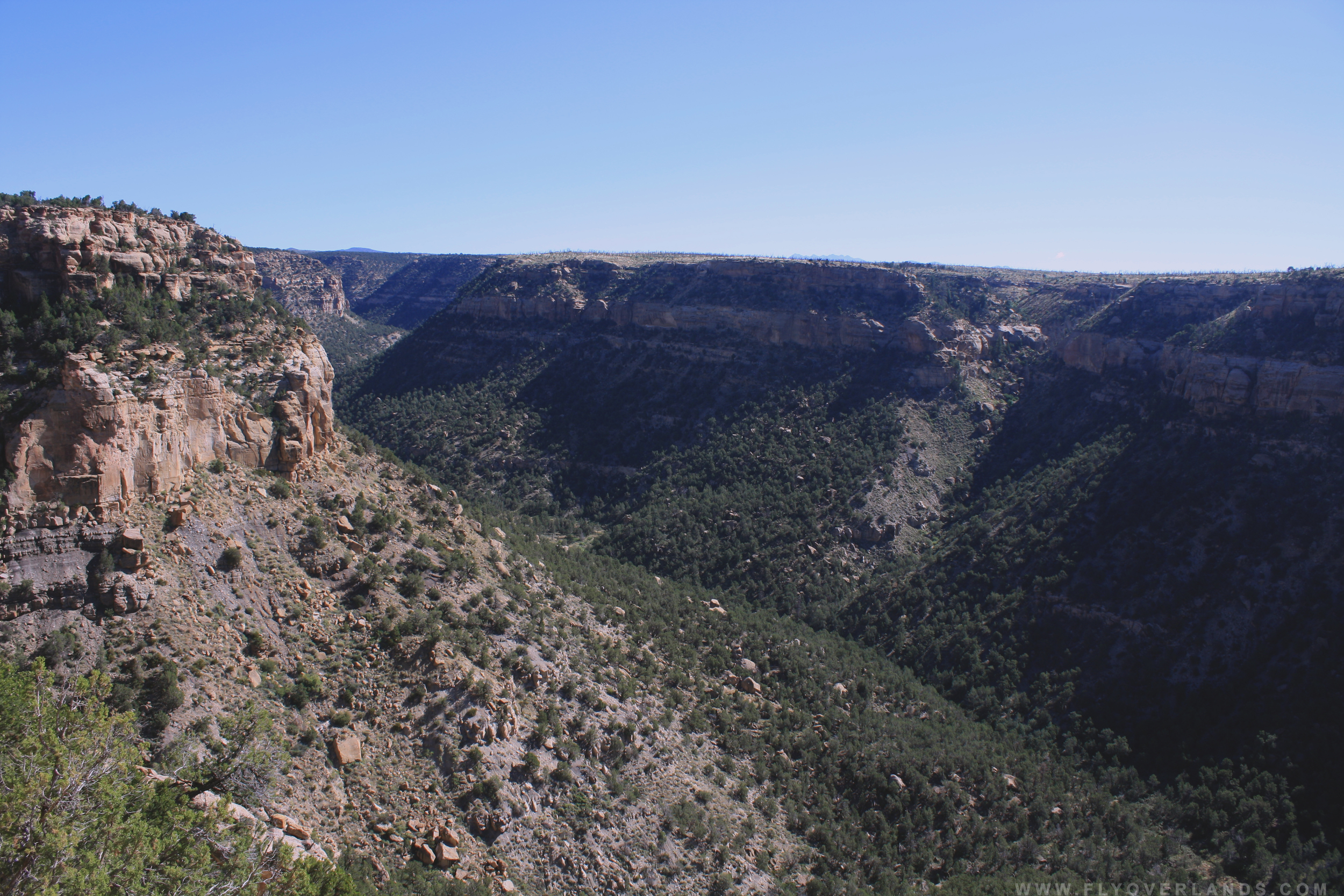
Located near the Four Corners (Colorado, Utah, Arizona and New Mexico), this “green table” is nestled at Colorado’s southwest pocket, at an elevation of 7000 - 8500 ft (psh, not high at all).
The drive up to Mesa Verde was steep and precarious, with the dusty grass as the only barrier separating road from cliff edges. When I finally rounded the last terrifying turn, I got a breathtaking glimpse of why this park was vital aspect of every middle schooler’s history lesson.
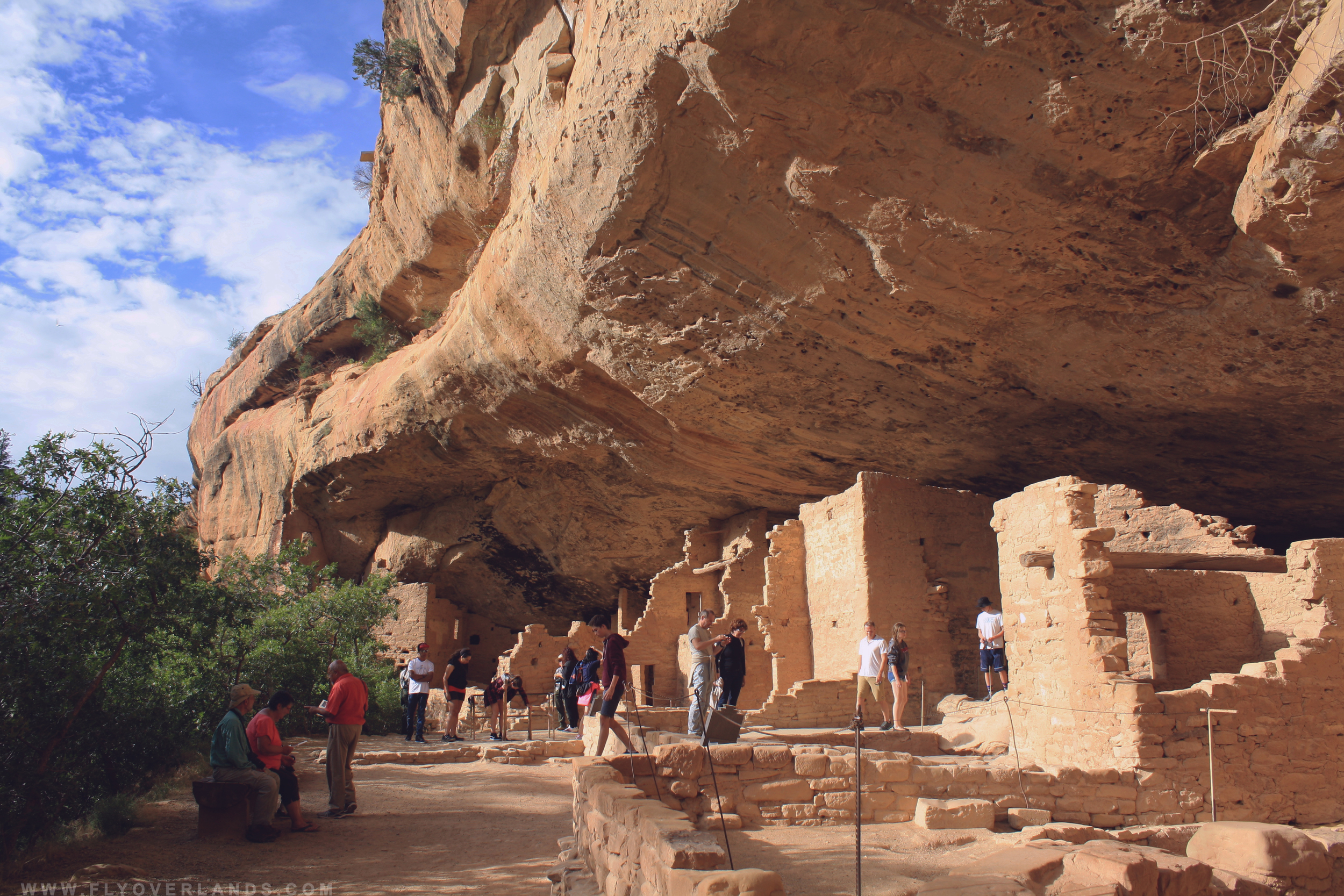
This elevated destination is not only a National Park, but is the largest archeological preserve in the United States.There are over 600 cliff dwellings still standing within the park’s limits, the most famous of these being the Cliff Palace (the largest cliff dwelling in North America and probably the one pictured in your history book!). And a few of these preserved ancestral homes are open to visitors.
This mountainous park is bursting with history, wildlife and opportunities for adventure seekers.
I was late as usual. When I arrived at the park in the afternoon, the summer sun was still beating down heavily. But small herds of smiling families, linked together by vice-link hand holds, meandered the parking lot in search of their vehicles as I swerved into a spot.
I ran into the information center, almost knocking into several of those little chain-linked families, in search of a map and a bathroom (the drive in was very long). I grabbed a map, Spruce Tree House was open to the public. Spruce Tree House was one of the only self-guided dwellings open, due to it’s proximity to the ground and easy-footed terrain. And I had an hour before the site closed. Since many other dwellings open to tour were very high up in the cliff and didn’t have infrastructure built around them to hold large groups, you had to be brought in by a ranger.
While less hazardous than other sites, Spruce Tree was still a trek in the heat of this summer evening. Starting from the peak, I had to take several staircases and switchbacks down the steep incline. However, this first glimpse of Mesa Verde’s rich history was worth it.

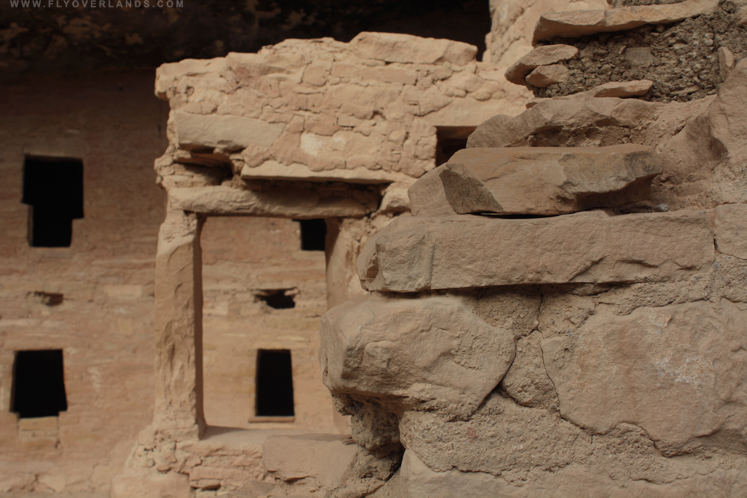
It was something you read about and heard about, but didn’t quite imagine it in its reality. Nestled within an alcove of the cliff, warm brown stone walls stood erect and seemingly sturdy.
Spruce Tree House would inspire the most apathetic of persons to transform into a history nerd. This wasn’t a decrepit fossil that you had to squint in concentration to imagine the life it once breathed, but a still standing, perfectly preserved home used 1400 years ago by a badass people who braved cliff faces and soaring heights.
The occupants were the ancestral Puebloans, otherwise known as the Anasazi. They built communities in the cliffs of Mesa Verde and thrived for about 700 years before moving on and settling elsewhere. At the time the cliffs provided shelter, safety and access to water.
I had definitely joined the end of the day rush. By the time I reached the bottom, crowds buzzed around the site snapping a few last photos and catching the tail-end of ranger-led tours, pointing out handprints in the clay and explaining the function of different rooms.
I started back up the steep pathway to my car, falling in line next to a park ranger. I told her I wanted to go into one of the ranger guided houses the next day.
“Definitely go see Balcony House! It has the best views and you’ll get to see a kiva* and a lot of climbing.”
“Cool! Thanks!”
“Wait...but are you OK with heights? If not, DO NOT do it. Although I saw a three year old on the tour last week...eh you’ll be fine.”
She sped on ahead of me to unlatch the gate and yell instructions to the stragglers. I couldn’t be more clumsy that a three year old. Balcony House it was!
My tour began at 8AM the next morning, so I left my campsite around 6:30. The drive up the mountains from the Mesa Verde campsite was about forty-five minutes of the steepest, twistiest roads I had encountered thus far. When I was brave enough to break focus and look, the views were extraordinary.
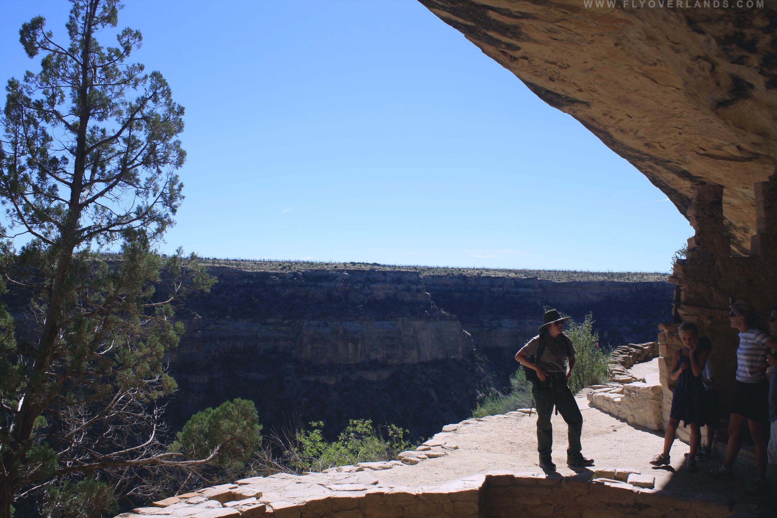
I joined the group of about thirty who were standing by the trail entrance on the parking lot pavement. The group spanned all ages; from a middle-aged couple snapping photos in their hiking gear, to small families loading up on snacks and water, to a group of European twenty-somethings laughing about the night before. Our ranger guide appeared and beckoned us to come closer for instructions. She warned us that it was a hike and it was imperative that we keep drinking water (the desert climate is hot, dry and it is very easy to become dehydrated).
“If any of you are afraid of heights this is not the tour for you. We will get to a steep ladder, this is your last opportunity to turn around. Do not be embarrassed about 50% will head back.”
Intimidating. In my peripheral a five year old was jumping off his father’s back onto the asphalt, oblivious to any potential dangers of the day.
If this little nugget can do it, so can I. I mean come on.
We began down the steep trail, which lined the edge of a large canyon. Eagles circled above, soaring across the epic crevice. What a kingdom.

The trail began to elevate as we inched toward the peak and the hike became harder and hotter. The ranger stopped us and we circled around, taking deep sips of water and wiping sweat from our brows. When I mustered the energy to look up, we had reached a giant ladder scaling the cliff face.
“This is your chance to turn back. Just don’t look down if you climb.”
Looking down meant looking down the depth of the huge canyon this dwelling was built into. The little five year old and his dad started to scale, his dad behind him for support. I approached the ladder and took the first step.
Not so bad.
It was a slow climb. The ladder was super-sized to fit the cliff face so there was a wide gap between each step. You wanted to be sure about your footing. The ranger assured us that even if someone launched themselves backwards we would be fine, but not to do that. By the time I was two thirds up the ladder my stomach turned. I looked down. This was not for the faint hearted.
I reached the top and someone held out a hand to pull me up. I hugged the stone wall of the cliff, so happy to be on solid ground. But then I turned around. The view was spectacular. We had a glimpse of what those surveying eagles see everyday.
We rounded the corner to Balcony House, a group of dwellings nestled into the rock, with nothing separating them from the cliff drop off. Like Spruce Tree, the walls were preserved in a similar style. However, Balcony House was obviously much higher up, and had a kiva dug into its foundation and sticks protruding from the stone wall. While you might think it’s the view, the sticks are what inspired the name. These were used as foundations for little balconies outside the windows, where people would sit and take in the view.
The Balcony House is believed to be a middle-sized dwelling with about ten rooms, plazas, kivas and tunnels. It was a community built for several families.
Though still erect, these walls are delicate artifacts and the oil from our hands can be detrimental. If touched often the oil can erode the rock, leaving a blackish smudge. The ranger gave close instructions on where to touch and step. After taking in the views, we were led through a tight tunnel used to enter different family homes. I had to squeeze through and at one point crawl on my hands and knees through a damp dark hallway.

After walking through several rooms, we made our ascent up to another ladder. It was smaller, thank god. Climbing quickly, only looking ahead I pulled myself up to the stone floor. I was now on a cliff face, a foot wide, with only a chain-link fence between me and the edge. This was far more terrifying than any ladder. I turned facing the cliff, heart beating through my throat and inched toward the first switchback. Tour mates ahead of me stopped, breathed deeply and exclaimed about the beauty of the view. I shot them a fiery look.
MOVE ALONG. I WANT TO LIVE.
After about five minutes of terror scaling, I reached the peak. This was where you safely admire the view people. To my surprise we were only a few steps away from the parking lot where we had met. On shaky legs I walked over to the fence and looked over the horizon, and listened to the next tour group get their warning.
It was an exhilarating step through time. And unlike that middle school history lesson, it will definitely stick.
* "Kivas is a Hopi word used to refer to specialized round and rectangular rooms in modern Pueblos" (http://www.nps.gov/museum/exhibits/chcu/slideshow/kivas/kivasintro.html)

by Cassia Reynolds
Disclaimer: I’m not a big fan of touristy stuff.
I still visited Mount Rushmore. It was one of those you’re-in-South-Dakota-and-you’re-NOT-going-to-do-the-one-thing-people-do-in-South-Dakota-and-for-the-love-of-the-friggin-bald-eagle-aren’t-you-American things. The image of those four dead guys chiseled into that rock has been carved into my brain since I can remember. It’s not just a national memorial. It’s the (excuse the pun) commander in chief of national memorials.
So I waited in the 45-minute car line with every other freaking road tripper in South Dakota, chipped in for the $11 parking fee, and made my way up the stone walkway to have a little face time with Washington, Jefferson, Roosevelt, and Lincoln.
And in the few hours that I spent at and around the Mount Rushmore national memorial, I had several revelations. Here’s the first.
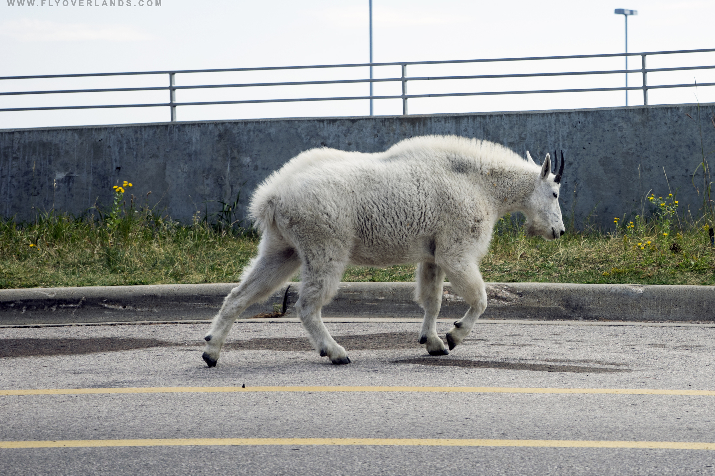
It was a long, crowded walk from the megamall-esque parking garage to the memorial. I was attempting to dodge a herd of screaming children when a woman’s gasp pierced the air. Mutterings of awe echoed through the congregations. I peered ahead and glimpsed a large creature with shaggy white fur, sharp, curved horns, a long snout, and a heavy-set, muscular frame.
Yeti!?
And because my natural instinct when I think that I finally have the chance to meet the Abominable Snowman is to say ‘hi,’ I scrambled past the people in front of me. I was so focused on my possible encounter that I didn’t notice the wide berth everyone else had given this furry visitor. Then I heard a child cry out, “billy goat!”
Forgive my ignorance of America’s wildlife, but I’d only ever seen mountain goats on Discovery Channel. And they just didn’t look this monstrous. Maybe because they were clambering over steep cliffs and enormous mountains, not standing in a pedestrian crosswalk. But I couldn’t help thinking in that moment that damn, I know nature in essence is beautiful, this is one ugly product of evolution.
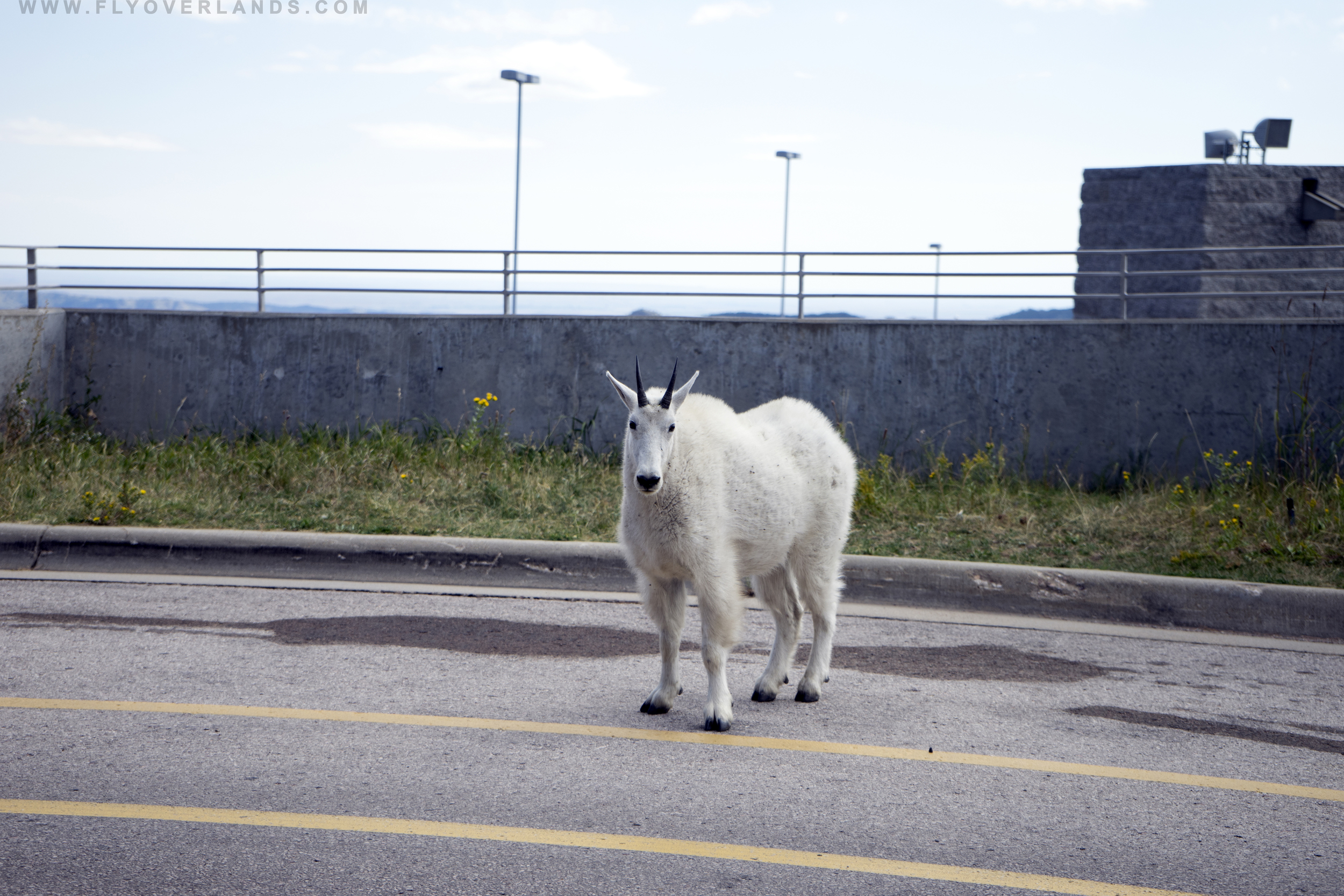
Now that I knew it was just a goat, I was fearless (In hindsight, I’m an idiot). My camera was out and I was snapping away, quickly closing the distance between it and myself. When I was about ten feet away, I crouched down for a better angle.
The goat heard the incessant clicking of the shutter or maybe just smelled my arrogance and it turned toward me. I lifted my eye away from the viewfinder and found myself staring into the those bottomless, jet pupils.
And that’s when I heard the security guard behind me shouting at the top of his lungs. “Don’t take another step closer! Everybody stay back!”
Oh, shiiiiiiit.
I kept eye contact, slowly lifted my left foot, and scooched backwards. The goat took a step forward.
How sharp are those horns?
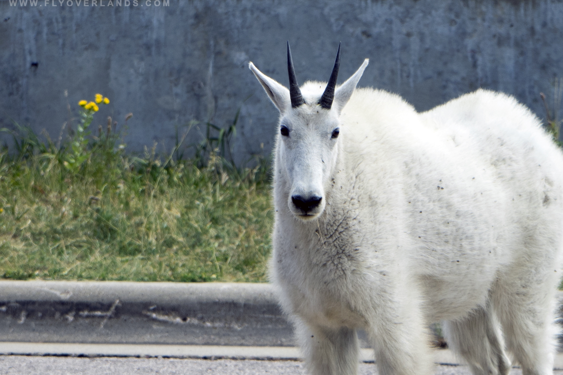
Another step toward me. And because if nothing else I am a documentarian, even if it’s of my own possible death, I noticed that the lighting was fantastic at this angle. I lifted my camera back up to my face to take another photograph.
When I dropped eye contact, the trance broke, the goat lost interest and continued on its way. I scrambled backward, dodging the annoyed security guard and shaking off the chills running down my spine.
In all seriousness, meeting this mountain goat was no joke; no encounter with a wild animal is. In the past few years, there have been more and more reported incidents of mountain goats behaving aggressively toward people. Though the first and last report of death-by-mountain-goat-goring was in Washington in 2010, the reality is that encroaching on the territory of wild animals is stupid.
I’m not sure why this mountain goat decided to wander up to a crowded memorial site (possibly for salt, which these critters are known to scavenge for), but it had obviously been around humans enough that its natural skittishness was gone. And that’s not necessarily a good thing. A huge part of what makes America’s national parks and natural landscape so incredible is the ecological diversity, the one that isn’t domesticated. Bears, mountain lions, eagles, deer; all these creatures have their own niche that defines the larger environment.
Mountain goats were introduced to South Dakota’s ranges in the 1920’s when several escaped from an enclosement in Custer State Park. Within twenty years, they had grown from a population of 10 to upwards of 400. Still, this region is technically new to these creatures. Even though men brought them to this area, it’s probably best for them to find their place in this unnatural habitat with as little extra human interaction as possible. And for the sake of science, it’s even more difficult to study the effects of an invasive species on a site if there are outside influences affecting the activities of that species. Here are some tips from the United States Department of Agriculture if you ever find yourself hiking in a goat’s environment:
Just in case you do find yourself face-to-face with an especially irritable creature, Slate wrote an article on what you should do if attacked by a mountain goat. And as my last piece of mountain goat love, here’s a gift of absolutely adorable baby animal goodness: a video of a baby mountain goat braving rapids.
by Samantha Adler

by Samantha Adler
It’s that time of year again. When pumpkin takes over every flavor, decor and mind in America, the leaves begin to change, the air is crisp and cool, and the countdown to Halloween begins. It’s the perfect time to get a little spooky and talk about haunted adventures on the Mississippi.
The Great River Road runs parallel to the Mississippi, stretching from Minnesota to New Orleans (NOLA). I had hopped on the byway in Tennessee, taking it down through Mississippi and Louisiana enroute to NOLA. In addition to the beautiful, lush scenery, the area around the Mississippi has a rich and grim history of the pre-Civil War South.
The Great River Road is a must visit for any thrill-seeker, history buff or paranormal whisperer. The area is dotted with historic battlefields, plantation homes and businesses.. And if you’re lucky (or unlucky) someone from the past might just give you a tour.

I made several stops along the way touring a few old homes and plantations. Each place had a story about it’s lavish past: elegant parties, engagements and secrets whispered in the drawing rooms. However, these houses also held more grisly secrets: Civil War raids, slavery and rampant racial violence and deadly sickness.There is much haunting to be done. Ghosts have a particular staying power here and the river is a huge reason why. It’s believed water traps them and is closely connected to the spirit world. The owners of these houses acknowledge this, and most have had angels carved into the molding to guard the corners from any possible demons.

Anyone there? Tour guides suggest taking two photos in this haunted mirror.
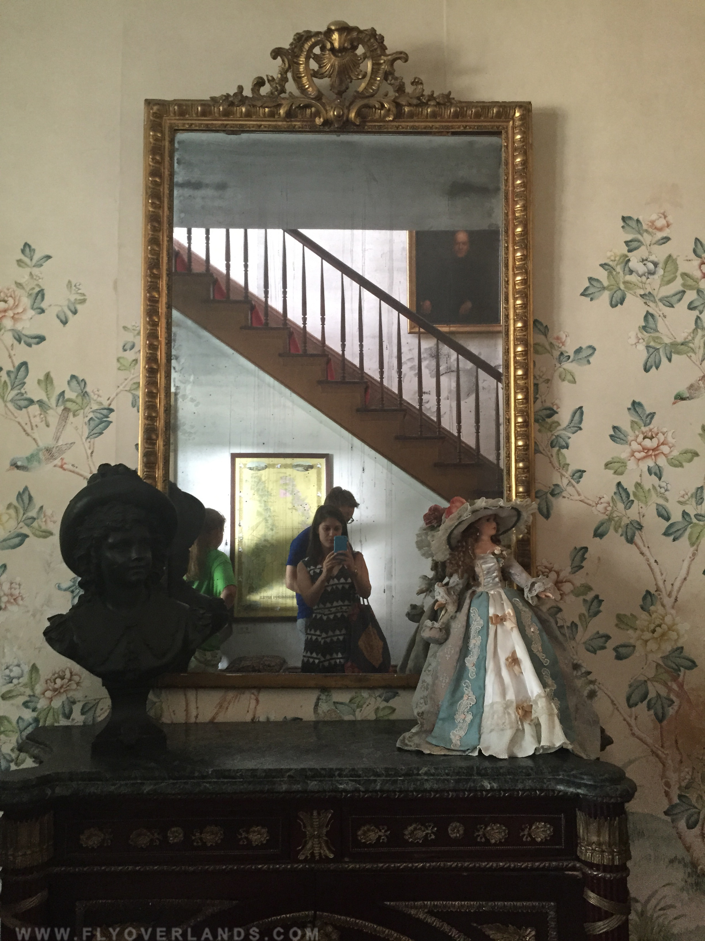
Some see dark shapes or shadows appear in their second take. (The Myrtles Plantation - Francisville, Louisiana)
Driving down the Great River Road took several days. In Louisiana, my road trip buddy and I got a cheap deal at the Nottoway Plantation, an old home that was converted into a hotel in White Castle, Louisiana. I was iffy on spending the night, considering its history as a working plantation, but agreed.
We arrived just in time for sunset...and an ill-timed spooky story. We checked in and set our bags down in our room. We were staying in a cabin off of the main house. While the room had few modern amenities, it looked as though it hadn’t been touched in decades. A large, wooden antique poster bed sat in the middle of the room, with a wood amour to its left. The walls held a few framed photographs of landscapes and an old tarnished brass mirror, whose reflective glass was cloudy with age.

After setting our things down, we headed to the restaurant bar located in the basement of the main house. The house is an enormous, strikingly white, Greek Revival style mansion with an iron-clad balcony stretching across its width. We made our way down, sat at the bar and began to chat with a few employees. A young waitress offered to take us to the second story balcony, the best place to watch the sunset. She led us through the restaurant and up the main staircase in the house.
The house boasts a few rooms for overnight guests, but is otherwise kept in its original condition for tours. At this time of day the house was dimly lit as we made our way through a large hall. The balcony was surrounded by a black iron railing and boasted a few rocking chairs for visitors. We took a seat and started to rock, watching the sun dip behind the Mississippi. Our guide turned around to walk back downstairs, but warned us that we might see a woman in a red gown. She was a member of the Randolph family, the original owners, and patrolled the house at night, looking over the home she worked so hard to create. And she had been dead for quite a long time.
I’m the type who begs to watch a horror movie, then immediately, deeply regrets that decision. I was the one who stupidly asked about hauntings at Nottoway. The waitress had begun to tell us about another friendly spirit of a coachman, who still liked to help people with their luggage. The potential friendliness of both ghosts was lost on me. I began to sip, no chug, my drink. The orange sun had almost completely been swallowed by the Mississippi, casting a warm, red light. I glanced behind, the interior of the house was now dark and shadows danced in the evening light. I grabbed my peaceful, sunset-loving companion and bolted towards the staircase. Like the house, the stair was grand with many, too many stairs. After running/sprinting down the main stairwell of the house and nearly smashing into the basement wall, we thanked our guide and left for our cabin.

We unloaded our bags and set in for an early night. I would fall asleep then shoot up expecting to see a confederate soldier sitting on the edge of my bed or little children asking me to play some creepy game. After the third heart attack, I decided to sit up for remaining 8 hours with the light and every electronic blaring. Safe to say I staved off any lady of the house, soldier or ghost of any sort.
While I avoided any encounters, I heard countless stories of paranormal run-ins on the Great River Road. From ghosts stealing earrings, to appearing in mirrors and developed film negatives. My journey was ghost free, but you might get lucky.

by Samantha Adler
Graceland was a major stop on my cross-country road trip. I am a life-long Elvis fan who comes from a long line of Elvis fanatics (my grandmother was once one of those screaming girls heard in all his live recordings). I reserved tour tickets a month in advance for my last morning in Memphis. But I had begun to see signs of the King way before I arrived in Memphis. I couldn’t pass through any establishment in Tennessee without seeing his face on the wall or hearing at least one of his top hits. It was the perfect build-up.
I arrived at Graceland early Sunday morning and waited in line with about fifty other eager beavers. Elvis’s estate, for all intensive purposes, has been turned into a theme park with gift shops, ice cream stands, restaurants serving his favorite banana and peanut butter sandwich and a well-oiled bus system. But I gleefully soaked up all the cheese.

My love for Elvis began in the 3rd grade when I had to do a report on a singer from the 1950s. His effortless cool and the way he took the world by storm fascinated me. I took out book after book from our school library about the late singer. I learned he quickly became an icon with an original style, blending blues and pop to create Rock and Roll. The assignment spurred conversations with my grandmother about her admiration. She had seen him perform in concert and even got into a fight with a girl for a scarf he threw into the audience. As time went on I became obsessed, I dressed as Elvis for Halloween and put on lip-sync performances for family. I even came up with a weird conspiracy theory about how The Beatles’ rise and Elvis’s mid-career fall were linked, and refused to listen to any Beatles song for a year. I was a weird, passionate and ill-informed kid.
The Graceland tour was led by John Stamos (yes, Uncle Joey) via a personal iPad that hung around my neck and airline-esque headphones. John Stamos explained about the grounds as the bus weaved through the front lawn towards the house. It was a small, white colonial-revival style mansion with two floors and a basement. A few rooms were filled with extravagant items: original china, chandeliers, guitars and art pieces. But most were designed for living, with a few personal items strewn about on shag carpets and 70’s décor.

The living/ jungle room*, perhaps the most famous room, was niche but homey with green shag, animal print, musical instruments, comfy looking couches and a teddy bear in residence. This was my favorite room of the house, as I’ve always dreamed of a bedroom designed after the Rainforest Cafe. I guess Elvis and I have similar taste, although Elvis’s take on it was a bit more posh.

Little did I know, this was only the beginning of the Elvis road trip.
I set off, leaving Memphis to drive down the Mississippi. I followed the Blues Highway along the big river, stopping occasionally at places that marked milestones in the blues music’s birth and evolution. Elvis is a huge part of the genre’s contemporary musical history, bringing blues basics and style into the pop spotlight. And he was still a treasure along the way, his music ringing in local restaurants and his face etched on gas station souvenirs.
These reminders had “Elvis & Me” burning a hole in my luggage. It wasn’t long before I was sneaking a read during downtime at campsites and in the passenger seat after my driving shift. It isn’t a brilliantly written novel, not even close. But it gives a rare view into the life of an untouchable icon and broke down the walls fame had put up. Elvis and Priscilla met when she was only fourteen, right after he had made his big break in the late fifties. The book was Priscilla’s perception on their marriage, his creative processes and his private life. While wildly talented, it turns out he was somewhat of a child who didn’t understand boundaries or the purpose of negative feedback. I did take everything with a grain of salt, considering that the author was his ex-wife and the cover art was everything about the 80’s you hated. It was nice however, to view this deity that followed us around as human.
When I made it to Vegas, he was everywhere again. Elvis impersonators walked the strip and his face was plastered all over as if he was joining Celine Dion in a headlining gig. As I learned in Graceland’s Museum, Vegas was where Elvis made his huge comeback. Returning from failed Hollywood endeavors, he started to perform live again. This is when the famous embezzled jumpsuits were coined and the bigger-than-life image of Elvis we know today was born. His success on the stage brought upon “Elvis: Aloha from Hawaii”, a live TV performance. It broke records, with more people watching Elvis than the first man to walk on the moon, and solidified his place as the King of Rock’n’Roll. This was the Elvis that my younger self impersonated with a glittery plastic jumpsuit, wiry black wig and adhesive sideburns.

This is also where I finished up “Elvis and Me”. My road trip buddy and I found an amazing, unbelievable deal for a room at the Vdara when we were mapping out our trip (always check for weird deals*). A comfortable hotel room was heaven after five nights of camping in the temperamental SouthWest summer. Immediately we ran to the pool to escape the Vegas heat. After a dip, I sat by the pool guiltily hiding the cover of my trashy biography from any fancy hotel walker-by. It felt appropriate to finish reading as we left a place to special to the story.
I had driven the Elvis road trip: through musical histories that inspired him, places of professional triumph and his private spaces. He had an amazing career and an extravagant life. But it’s the places he left that stick with me the most. These places have an electrifying energy, soaked in history and probably remnants of those Rock and Roll parties. These places are just as important to the story as the King himself.
* The Jungle Room serves as the den in the Graceland mansion. Its design has a Polynesian influence, known for its green decor, shag carpeting and waterfall lining the wall. The decision was based on Elvis’s favorite vacation spot: Hawaii. The room was later converted into a recording studio in the 1970’s.
* Look for deals on Bookings.com. You’d be surprised about what hotels/locations are offering cheap rooms! In this specific example the Vdara, a normally pricey hotel on the strip, we found a crazy deal a month in advance. We believe this is because the Vdara is one of the only big hotels without a casino. Always hunt for the discounts :).